1990s Maps of Franklin, Tennessee
Explore 1 historic maps of Franklin from the 1990s. These maps offer a rare glimpse into what life looked like during the 1990s — showing old roads, neighborhoods, homes, and landmarks that have changed or disappeared over time.
Whether you're researching your family's past, planning a metal detecting trip, or studying how Franklin's landscape evolved across the 1990s, these high-resolution maps are a powerful tool for exploring the history of this region.
- Focus on a specific era: All maps on this page are from the 1990s, giving you a focused view of this time period.
- See what’s changed: Compare century-old streets, trails, and buildings to today's modern landscape using overlays and satellite layers.
- Research with precision: Use these maps for genealogy, historical research, land use analysis, or educational projects.
- View, download, or print: Maps are fully viewable online in high resolution, and can be downloaded or printed for your own records.
Start exploring Franklin's history through authentic maps from the 1990s. This is your window into the past.
Franklin, TN maps
(1)- 1997 Map of Franklin, 2002 Print
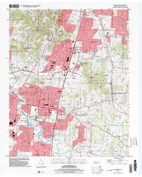 1997 Franklin2002 Print · USGSFranklin and Brentwood underwent significant growth in the late nineties as residential estates expanded across the Tennessee hills. Genealogists can trace family heritage through numerous burial grounds including Owen Cem, Crockett Cem, and the Confederate Cem.
End of results
Showing maps 1-1 of 1
Top cities near Franklin
- Nashville historical maps
- Smyrna historical maps
- Brentwood historical maps
- Columbia historical maps
- Spring Hill historical maps
- La Vergne historical maps
See more
Top neighborhoods of Franklin
- Westfield Estates historical maps
- Boyd Mill Estates historical maps
- Orleans Estates historical maps
- Charlton Green historical maps
- Country Roads historical maps
- Spencer Creek Place historical maps
See more
Frequently asked questions
- What are the different types of historical maps available for Franklin?
- What is the oldest map of Franklin?
- Where can I purchase historical maps of Franklin for my home or office?
- Where can I download high-res historical maps of Franklin?
- Are there historical topographic maps available for Franklin?
- Is there historical aerial imagery available for Franklin?
- Where are historical maps of Franklin sourced from?