Old Maps of Lufkin, Texas
Explore 15 old maps of Lufkin, spanning from 1949 to today. These high-resolution historic maps reveal how streets, neighborhoods, landmarks, and natural features evolved over time — perfect for genealogy, metal detecting, research, and local history exploration.
What you can do with these maps:
- See how Lufkin changed over time: Compare historical maps to modern-day views to trace roads, homesites, rail lines & more.
- View detailed metadata: Each map includes creators, publishers, year, scale, and archive source.
- Overlay maps with satellite & LiDAR: Visualize the past alongside modern tools to explore terrain & human change.
- Trusted historical sources: Maps sourced from the USGS, Library of Congress, and other archives.
- Access maps your way: View online, download high-res files, or order prints for personal or research use.
Start exploring old maps of Lufkin to uncover forgotten places, hidden landmarks, and the deep history beneath your feet.
Lufkin, TX maps
(15)- 1949 Map of Lufkin, 1961 Print
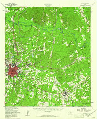 1949 Lufkin1961 Print · USGSPost-war Angelina County shows a growing Lufkin amid a landscape of timber and rail. Genealogists can trace family names through dozens of landmarks like Homer Cem, Jacob Chapel Cem, and the old settlement at Marion.2 unique versions available
 - 1949 Map of Lufkin, 1968 Print
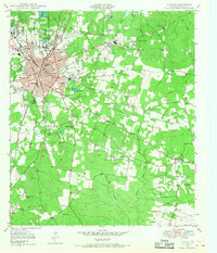 1949 Lufkin1968 Print · USGSLufkin and its surrounding East Texas timberlands are captured here at mid-century, showing the city's rail-driven expansion. Genealogists and local historians can locate several family burial grounds like Whitehouse Cem and Fielder Cem, alongside rural landmarks such as Harbucks Chapel.3 unique versions available
 - 1949 Map of Keltys, 1977 Print
 1949 Keltys1977 Print · USGSAngelina County in the late 1940s reveals a landscape defined by timber-era railroads and rural community hubs. Researchers can trace family roots at Largent Cem or explore the development of Keltys and the Agricultural Experiment Station.2 unique versions available
 - 1950 Map of Keltys
 1950 Keltys1950 Print · USGSAngelina County saw significant growth in the early post-war years as the rail lines connected rural timberlands and towns. Genealogists can trace family names at Wallace Cem, Hudson Sch, and New Hope Ch.
 - 1950 Map of Lufkin
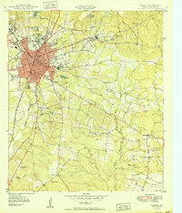 1950 Lufkin1950 Print · USGSMid-century Lufkin serves as a vital rail and industrial hub in the East Texas timber belt as it appeared just after the war. Local historians can trace the foundations of the community at Keltys, Homer, and rural sites like Harbucks Chapel or Glendale Cem.
 - 1950 Map of Redland
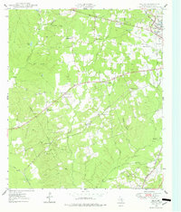
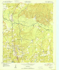 1950 Redland1950 Print · USGSThe Angelina River valley in the early fifties was a landscape of bayous and new infrastructure. Local historians can trace the paths of the Southern Pacific and locate family landmarks like Walker Cem, St Anns School, and the settlement of Davisville.4 unique versions available
 - 1953 Map of Palestine, 1964 Print
 1953 Palestine1964 Print · USGSEast Texas was defined by its deep pine forests and burgeoning energy sector in the mid-1950s. Genealogists and historians can trace the rail-and-river economy through settlements like Tennessee Colony and Pollok or explore the early footprints of the Cayuga Oil Field and Davy Crockett National Forest.2 unique versions available
 - 1957 Map of Palestine
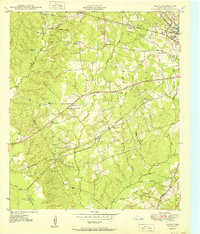
 1957 Palestine1957 Print · USGSEast Texas in the mid-fifties reveals a landscape of deep pine forests and winding river valleys before the era of massive reservoir construction. Researchers can trace the legacy of the timber and rail industries through labels for the Missouri Pacific RR, Davy Crockett National Forest, and Nacogdoches.
 - 1984 Map of Palestine
 1984 Palestine1984 Print · USGSEast Texas in the mid-eighties reveals a landscape of massive reservoirs and protected timberlands between Palestine and Nacogdoches. Researchers can trace old routes like the Missouri Pacific RR and locate rural communities such as Tennessee Colony, Latexo, and Etoile.3 unique versions available
 - 1986 Map of Lufkin
 1986 Lufkin1986 Print · USGSDeep in the Piney Woods during the mid-eighties, this map documents a landscape shaped by vast national forests and the waters of the Sam Rayburn Reservoir. Researchers can trace the legacy of timber and rail through settlements like Diboll, Herty, and Ewing alongside the St Louis Southwestern railroad.
 - 1992 Map of Lufkin
 1992 Lufkin1992 Print · USGSThe Piney Woods of East Texas are captured here in the early nineties, centered on the growing industrial hub of Lufkin. Local researchers can trace the rail networks of the Angelina & Neches River RR and locate rural landmarks like Shady Grove Ch and Manning.
 - 2003 Map of Redland, 2004 Print
 2003 Redland2004 Print · USGSThe East Texas piney woods are captured here in the early 2000s, showing the intersection of heavy industry and national forest land. Genealogists can trace family landmarks like Walker Cem, Davisville Ch, and the site of St James School.
 - 2022 Map of Lufkin, 2022 Print
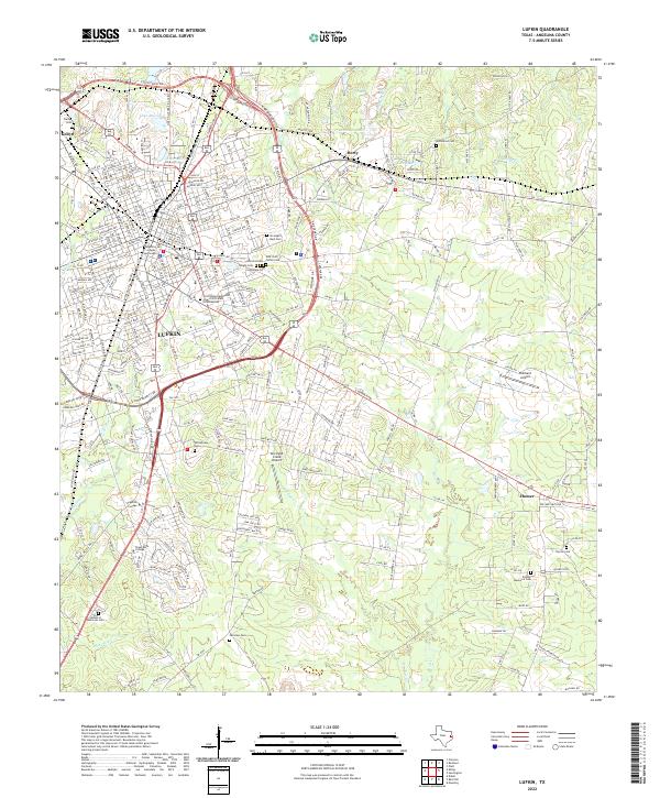 2022 Lufkin2022 Print · USGSLufkin and its surrounding East Texas communities are captured here in the early 2020s, showing a landscape defined by collegiate growth and civic history. Trace family roots at Garden of Memories Cem or Homer Cem, and locate landmarks like the Angelina County Courthouse.
 - 2022 Map of Redland, 2022 Print
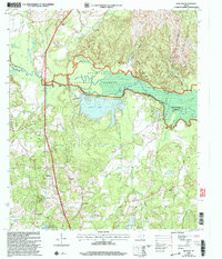
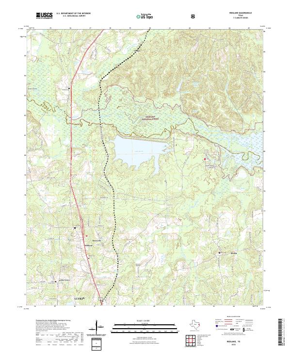 2022 Redland2022 Print · USGSThe Angelina River basin north of Lufkin shows a landscape of dense national forest and vital water resources in the early 2020s. Genealogists and historians can locate family burial sites like Walker Cem and trace the proximity of Redland to Lake Kurth.
 - 2022 Map of Keltys, 2022 Print
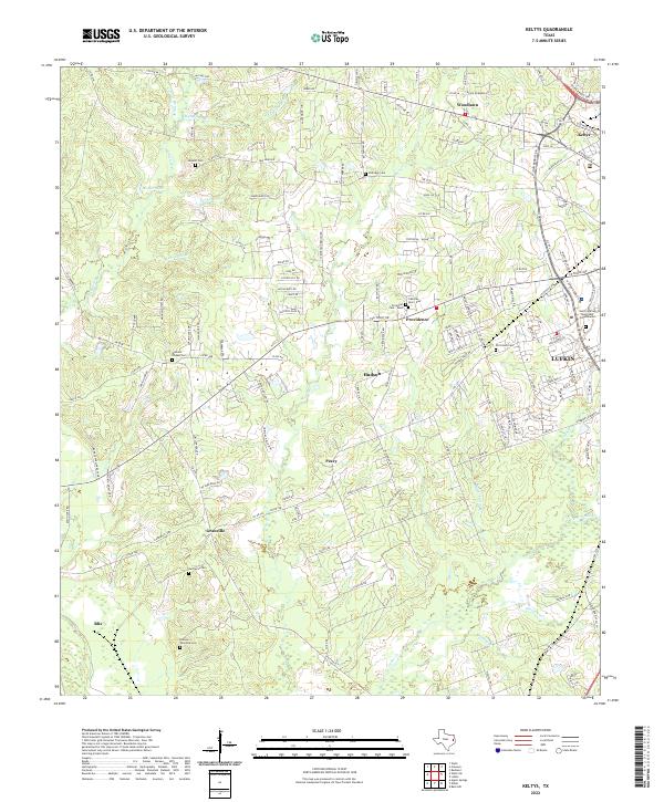 2022 Keltys2022 Print · USGSThe northern outskirts of Lufkin and surrounding rural Angelina County are captured in this modern survey. Genealogists can trace family burial sites at Old Union Cem, Narraway Cem, or the small settlements of Peavy and Keltys.
End of results
Showing maps 1-15 of 15
Top cities near Lufkin
- Diboll historical maps
- Hudson historical maps
- Huntington historical maps
- Redland historical maps
- Wells historical maps
- Burke historical maps
Top neighborhoods of Lufkin
Frequently asked questions
- What are the different types of historical maps available for Lufkin?
- What is the oldest map of Lufkin?
- Where can I purchase historical maps of Lufkin for my home or office?
- Where can I download high-res historical maps of Lufkin?
- Are there historical topographic maps available for Lufkin?
- Is there historical aerial imagery available for Lufkin?
- Where are historical maps of Lufkin sourced from?