1940s Maps of Bastrop County, Texas
Explore 4 historic maps of Bastrop County from the 1940s. These maps offer a rare glimpse into what life looked like during the 1940s — showing old roads, neighborhoods, homes, and landmarks that have changed or disappeared over time.
Whether you're researching your family's past, planning a metal detecting trip, or studying how Bastrop County's landscape evolved across the 1940s, these high-resolution maps are a powerful tool for exploring the history of this region.
- Focus on a specific era: All maps on this page are from the 1940s, giving you a focused view of this time period.
- See what’s changed: Compare century-old streets, trails, and buildings to today's modern landscape using overlays and satellite layers.
- Research with precision: Use these maps for genealogy, historical research, land use analysis, or educational projects.
- View, download, or print: Maps are fully viewable online in high resolution, and can be downloaded or printed for your own records.
Start exploring Bastrop County's history through authentic maps from the 1940s. This is your window into the past.
Bastrop County, TX maps
(4)- 1948 Map of Smithville, 1956 Print
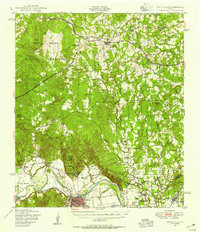 1948 Smithville1956 Print · USGSBastrop and Fayette counties are captured here shortly after the war, showing the footprint of military expansion alongside traditional river life. Genealogists can locate family landmarks like Milton Chapel Cem, Crafts Prairie Sch, and the rural community of Paige.2 unique versions available
 - 1948 Map of Elgin, 1969 Print
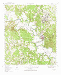
 1948 Elgin1969 Print · USGSCentral Texas in the late 1940s was a landscape of rail-junction towns and emerging military training grounds. Genealogists can trace rural family legacies through sites like Youngs Prairie Cem, the Camp Swift Military Reservation, and Red Town Sch.2 unique versions available
 - 1948 Map of Bastrop, 1972 Print
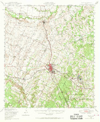
 1948 Bastrop1972 Print · USGSBastrop and its winding river bends are captured here in the late 1940s as the military and oil industries integrated with rural farming life. Trace the footprints of the Camp Swift Military Reservation or locate family sites at Bartons Farm, Woods Cem, and Shiloh Sch.
 - 1948 Map of Lexington, 1974 Print
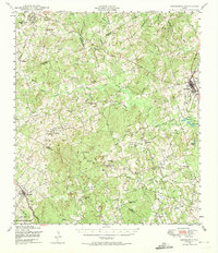 1948 Lexington1974 Print · USGSCentral Texas rural life in the late 1940s is captured here, showing the intersection of Lee, Milam, and Williamson counties. Genealogists can locate family burial sites at New Knobs Springs Cem and trace the influence of the Southern Pacific line through Lexington.
End of results
Showing maps 1-4 of 4
Top cities of Bastrop County
- Bastrop historical maps
- Smithville historical maps
- Circle D-KC Estates historical maps
- Rosanky historical maps
- McDade historical maps
- Alum Creek historical maps
Frequently asked questions
- What are the different types of historical maps available for Bastrop County?
- What is the oldest map of Bastrop County?
- Where can I purchase historical maps of Bastrop County for my home or office?
- Where can I download high-res historical maps of Bastrop County?
- Are there historical topographic maps available for Bastrop County?
- Is there historical aerial imagery available for Bastrop County?
- Where are historical maps of Bastrop County sourced from?