1980s Maps of Smithville, Texas
Explore 4 historic maps of Smithville from the 1980s. These maps offer a rare glimpse into what life looked like during the 1980s — showing old roads, neighborhoods, homes, and landmarks that have changed or disappeared over time.
Whether you're researching your family's past, planning a metal detecting trip, or studying how Smithville's landscape evolved across the 1980s, these high-resolution maps are a powerful tool for exploring the history of this region.
- Focus on a specific era: All maps on this page are from the 1980s, giving you a focused view of this time period.
- See what’s changed: Compare century-old streets, trails, and buildings to today's modern landscape using overlays and satellite layers.
- Research with precision: Use these maps for genealogy, historical research, land use analysis, or educational projects.
- View, download, or print: Maps are fully viewable online in high resolution, and can be downloaded or printed for your own records.
Start exploring Smithville's history through authentic maps from the 1980s. This is your window into the past.
Smithville, TX maps
(4)- 1982 Map of Winchester
 1982 Winchester1982 Print · USGSThe community of Winchester in the early 1980s sits at the crossroads of the Southern Pacific railroad and the Colorado River. Genealogists can trace family landmarks like St Marys Cem, Shiloh Cemetery, and the Center Union Community Center.
 - 1982 Map of Smithville
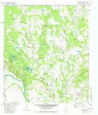
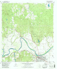 1982 Smithville1982 Print · USGSBastrop County at the start of the 1980s shows a landscape where the river-and-rail economy of the Colorado River meets the expanding Bastrop State Park. Genealogists and historians can trace old family sites like Hardeman Bend, Claiborne Cem, and the path of the historic Gotier Trace.2 unique versions available
 - 1985 Map of Austin
 1985 Austin1985 Print · USGSCentral Texas in the mid-eighties reveals a region in transition, balancing rapid urban growth in Austin with deep-rooted rural landscapes. Genealogists and historians can trace family locations near St Johns Ch, the Science Hall schoolhouse, and long-standing communities like Webberville and Manchaca.3 unique versions available
 - 1985 Map of Seguin, 1986 Print
 1985 Seguin1986 Print · USGSCentral Texas in the mid-1980s is defined by its vital oil industry and the crossroads of major interstate and rail networks. Genealogists and historians can trace the development of Luling Oil Field, identify the site of Old Flatonia, or locate family landmarks near St James and Palmetto State Park.2 unique versions available
End of results
Showing maps 1-4 of 4
Top cities near Smithville
- Bastrop historical maps
- Giddings historical maps
- Circle D-KC Estates historical maps
- Rosanky historical maps
- Alum Creek historical maps
Frequently asked questions
- What are the different types of historical maps available for Smithville?
- What is the oldest map of Smithville?
- Where can I purchase historical maps of Smithville for my home or office?
- Where can I download high-res historical maps of Smithville?
- Are there historical topographic maps available for Smithville?
- Is there historical aerial imagery available for Smithville?
- Where are historical maps of Smithville sourced from?