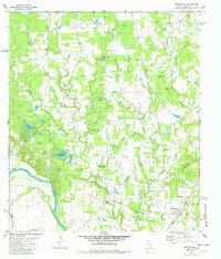
1982 Map of Winchester
USGS Topo · Published 1982About this map
The Colorado River winds through the southwestern corner of this Central Texas landscape, marking the convergence of Bastrop, Lee, and Fayette counties. The settlement of Winchester serves as the primary rail hub, situated at the intersection of the Southern Pacific line and local road networks. This 1982 map reveals a rural community structure deeply tied to local family and religious landmarks, with numerous burial grounds such as St Marys Cem, Washington Cem, and Shiloh Cemetery dotting the terrain between the creeks. The area is defined by its complex drainage system, where Pin Oak Creek and Little Pin Oak Creek flow toward the river. Land use is characterized by a mix of agricultural plots and wooded sections, with the Center Union Community Center and Pin Oak Ch serving as focal points for the dispersed population. Significant water features like Indian Lake, Lake Thunderbird, and Horseshoe Lakes offer a contrast to the surrounding prairie and woodlots.
Find a feature on this map
36 named features on this map. Tap any name to fly to it.
Don’t see what you’re looking for? This feature index may not catch every label — zoom into the map to look around manually.
Map Details
Editions of this 1982 Winchester Map
This is the sole edition of this map. No revisions or reprints were ever made.
Other maps of this area

1885 · Bastrop
USGS Topo · 1:125,000

1893 · Bastrop
USGS Topo · 1:125,000

1901 · Flatonia
USGS Topo · 1:125,000

1904 · Bastrop
USGS Topo · 1:125,000

1919 · Giddings
USGS Topo · 1:62,500

1948 · Smithville
USGS Topo · 1:62,500

1950 · Smithville
USGS Topo · 1:62,500

1953 · Seguin
USGS Topo · 1:250,000

1954 · Austin
USGS Topo · 1:250,000

1956 · La Grange
USGS Topo · 1:62,500