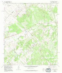
1968 Map of Lytton Springs
USGS Topo · Published 1994About this map
Lytton Springs serves as the focal point of this Central Texas landscape, where the intersection of Travis and Caldwell counties meets a network of historic thoroughfares. The presence of the Old San Antonio Road and several unimproved trails suggests a legacy of transit that predates the modern era, while the Elroy Oil Field in the northwest and numerous scattered Oil Wells and Drill Holes indicate a mid-20th-century economy driven by petroleum extraction. The drainage system is dominated by the winding path of Cedar Creek, which is flanked by the Lower Cedar Creek Cemetery and Upper Cedar Creek Cemetery. These burial grounds, alongside Saint Marys Ch and Mt Pleasant Ch, provide valuable landmarks for genealogists tracing family histories in these rural communities during the late 1960s.
Find a feature on this map
39 named features on this map. Tap any name to fly to it.
Don’t see what you’re looking for? This feature index may not catch every label — zoom into the map to look around manually.
Map Details
Editions of this 1968 Lytton Springs Map
3 editions found
Other maps of this area

1885 · Bastrop
USGS Topo · 1:125,000

1893 · Bastrop
USGS Topo · 1:125,000

1896 · Austin
USGS Topo · 1:125,000

1897 · Austin
USGS Topo · 1:125,000

1901 · Flatonia
USGS Topo · 1:125,000

1904 · Bastrop
USGS Topo · 1:125,000

1910 · Austin
USGS Topo · 1:125,000

1911 · San Marcos
USGS Topo · 1:125,000

1919 · San Marcos
USGS Topo · 1:125,000

1930 · Lockhart
USGS Topo · 1:62,500