
1901 Map of Flatonia
USGS Topo · Published 1901About this map
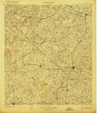
Ethnic enclaves and railroad expansion characterize this late nineteenth-century landscape at the convergence of Bastrop, Fayette, Caldwell, and Gonzales counties. The map documents several distinct social geographies, including the Bohemian Settlement, German Settlement, and Negro Settlement, providing a rare spatial view of how community identity was mapped during the post-Reconstruction era. The arrival of the iron horse is evident through the branching corridors of the Southern Pacific R. R. and the Missouri Kansas and Texas R. R., which stimulated growth in towns like Waelder and Flatonia. A notable genealogical detail appears in the shift of town sites, as seen in the distance between the established rail stop and Old Flatonia, or the rural positioning of Hickston P. O. (Mt. Eaton). The terrain remains largely agricultural, drained by the Colorado River and Peach Creek, with local landmarks like Burkett Mound anchoring the southern reaches near Moulton.
Find a feature on this map
124 named features on this map. Tap any name to fly to it.
Don’t see what you’re looking for? This feature index may not catch every label — zoom into the map to look around manually.
Map Details
Editions of this 1901 Flatonia Map
2 editions found
Other maps of this area

1885 · Bastrop
USGS Topo · 1:125,000

1893 · Bastrop
USGS Topo · 1:125,000

1896 · Austin
USGS Topo · 1:125,000

1897 · Austin
USGS Topo · 1:125,000

1904 · Bastrop
USGS Topo · 1:125,000

1910 · Austin
USGS Topo · 1:125,000

1911 · San Marcos
USGS Topo · 1:125,000

1919 · Giddings
USGS Topo · 1:62,500

1919 · San Marcos
USGS Topo · 1:125,000

1919 · Schulenburg
USGS Topo · 1:62,500