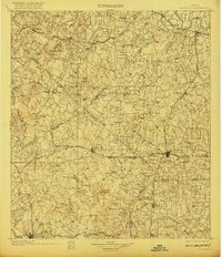
1901 Map of Flatonia
USGS Topo · Published 1920About this map
Central Texas ranching and farm lands at the turn of the century are defined here by a dense network of ethnic enclaves and small rail hubs. The rail junction at Flatonia serves as a primary focal point, situated along the Southern Pacific RR and the San Antonio and Aransas Pass RR. The social landscape of the era is remarkably visible through labels such as the Bohemian Settlement, German Settlement, and Negro Settlement, indicating the distinct community clusters that shaped local history. Further south, Old Flatonia stands apart from its namesake rail-stop successor, while industrial sites like Winfield's Grist and family-named landmarks like Possunntrot and Royston Hill provide specific points of interest for genealogists tracing ancestors in the Bastrop, Caldwell, Fayette, and Gonzales county borderlands. The winding Colorado River clips the northeastern corner near West Point, anchoring a landscape otherwise drained by numerous creeks like Peach Creek and Buckner Creek.
Find a feature on this map
77 named features on this map. Tap any name to fly to it.
Don’t see what you’re looking for? This feature index may not catch every label — zoom into the map to look around manually.
Map Details
Editions of this 1901 Flatonia Map
2 editions found
Other maps of this area

1885 · Bastrop
USGS Topo · 1:125,000

1893 · Bastrop
USGS Topo · 1:125,000

1896 · Austin
USGS Topo · 1:125,000

1897 · Austin
USGS Topo · 1:125,000

1901 · Flatonia
USGS Topo · 1:125,000

1904 · Bastrop
USGS Topo · 1:125,000

1910 · Austin
USGS Topo · 1:125,000

1911 · San Marcos
USGS Topo · 1:125,000

1919 · Giddings
USGS Topo · 1:62,500

1919 · San Marcos
USGS Topo · 1:125,000