1896 Map of Austin
USGS Topo · Published 1896About this map
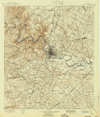
Austin serves as the focal point of this late-nineteenth-century landscape, positioned at a critical bend in the Colorado River where the coastal plains meet the higher elevations of the Jollyville Plateau. The map reveals a river-dependent economy in the era before widespread bridging, documented through numerous river crossings such as Sylvester Ford, Stones Ford, and the Cameron Ferry. The city's early development is marked by the City Dam and institutions like Saint Edwards College, while the surrounding countryside is a network of small agricultural settlements and rural centers including Manor, Pflugerville, and Montopolis.
Find a feature on this map
124 named features on this map. Tap any name to fly to it.
Don’t see what you’re looking for? This feature index may not catch every label — zoom into the map to look around manually.
Map Details
Editions of this 1896 Austin Map
This is the sole edition of this map. No revisions or reprints were ever made.
Historical Maps of Austin Through Time
6 maps found