1919 Map of Giddings
USGS Topo · Published 1919About this map
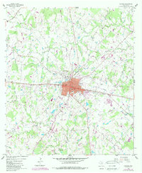
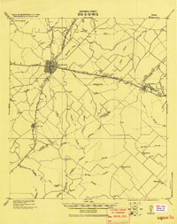
Giddings P.O. serves as the central hub of this 1919 military survey, where the Houston and Texas Central Railroad intersects with the San Antonio and Aransas Pass Railway. This era of Texas history is defined by a dense network of rural post offices and small settlements such as Northrup P.O., Warda P.O., and the Lutheran community at Serbin. The landscape is etched with the drainage patterns of Rabbs Creek and Nails Creek, while industrial activity is noted at the Kruse Quarry near Cummins. Beyond the main rail lines, the map identifies numerous school houses, simply labeled S.H., and early landmarks like the Willy Branch School, providing a detailed view of the social and economic infrastructure in Lee and Fayette Counties before the modern highway system reshaped the region.
Find a feature on this map
44 named features on this map. Tap any name to fly to it.
Don’t see what you’re looking for? This feature index may not catch every label — zoom into the map to look around manually.
Map Details
Editions of this 1919 Giddings Map
This is the sole edition of this map. No revisions or reprints were ever made.
Historical Maps of Giddings Through Time
7 maps found