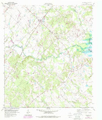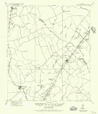
1919 Map of Dime Box
USGS Topo · Published 1956About this map
Dime Box and its surrounding rural communities in Lee and Burleson counties appear here as they were organized following the first World War. This tactical survey, prepared under W. P. Stokey, illustrates the transition of the regional landscape as newer settlements like Dime Box P.O. grew along the Southern Pacific System tracks while the original townsite, now labeled Old Dime Box, remained a distinct landmark to the northwest. The area is defined by a dense network of watercourses including Yequa Creek and Brushy Creek, which shaped the placement of early road networks like the San Antonio and Dime Box Road. Small social hubs are scattered throughout the countryside, marked by numerous schools and churches such as Shady Grove School and a Church (Col), reflecting the segregated rural life of the era. To the west, the San Antonio and Aransas Pass Railway cuts through Lincoln P.O. and Tanglewood P.O., supporting the local agricultural economy.
Find a feature on this map
39 named features on this map. Tap any name to fly to it.
Don’t see what you’re looking for? This feature index may not catch every label — zoom into the map to look around manually.
Map Details
Editions of this 1919 Dime Box Map
This is the sole edition of this map. No revisions or reprints were ever made.
Historical Maps of Lexington Through Time
7 maps found