1900s (20th Century) Maps of Seymour, Texas
Explore 6 historic maps of Seymour from the 1900s (20th Century). These maps offer a rare glimpse into what life looked like during the 1900s — showing old roads, neighborhoods, homes, and landmarks that have changed or disappeared over time.
Whether you're researching your family's past, planning a metal detecting trip, or studying how Seymour's landscape evolved across the 1900s, these high-resolution maps are a powerful tool for exploring the history of this region.
- Focus on a specific era: All maps on this page are from the 1900s, giving you a focused view of this time period.
- See what’s changed: Compare century-old streets, trails, and buildings to today's modern landscape using overlays and satellite layers.
- Research with precision: Use these maps for genealogy, historical research, land use analysis, or educational projects.
- View, download, or print: Maps are fully viewable online in high resolution, and can be downloaded or printed for your own records.
Start exploring Seymour's history through authentic maps from the 1900s. This is your window into the past.
Seymour, TX maps
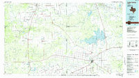
(6)- 1954 Map of Wichita Falls, 1966 Print
 1954 Wichita Falls1966 Print · USGSNorth Texas in the mid-fifties is captured here as a landscape of expanding oil fields and vital rail corridors. Genealogists and historians can trace family roots through rural landmarks like Bacon Chapel and the rail-side growth of Seymour and Archer City.3 unique versions available
 - 1958 Map of Wichita Falls
 1958 Wichita Falls1958 Print · USGSNorth Texas during the late fifties reveals a landscape defined by the booming petroleum industry and established rail hubs. Researchers can trace the development of Wichita Falls and discover rural landmarks like Barton's Chapel or the Hull-Silk Oil Field.
 - 1966 Map of Seymour West, 1968 Print
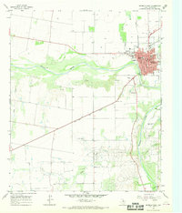 1966 Seymour West1968 Print · USGSMid-century Baylor County comes into focus as the community of Seymour expands near the Brazos River. Genealogists and historians can trace local landmarks like the Cache Creek Cem, the High Sch, and the rail corridor of the Fort Worth and Denver.
 - 1966 Map of Southwest Lake Kemp, 1969 Print
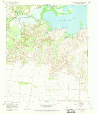 1966 Southwest Lake Kemp1969 Print · USGSBaylor County ranchlands and the expanding southern shores of the reservoir are documented here in the late sixties. Researchers can trace land use through Jones Cow Camp, the Seymour Municipal Airfield, and landmarks like Tabletop Mtn.
 - 1966 Map of Seymour East, 1969 Print
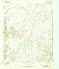 1966 Seymour East1969 Print · USGSBaylor County in the mid-sixties shows a landscape of cattle ranching and rail transit at the edge of the Brazos River. Genealogists and local historians can locate Riverside Cem, the settlement at Lively, and traces of an Old Railroad Grade.
 - 1985 Map of Lake Kemp
 1985 Lake Kemp1985 Print · USGSThe North Texas plains come into sharp focus in the mid-eighties as a region defined by its vast reservoirs and deep-rooted agricultural hubs. Genealogists and local historians can trace the rural landscape surrounding Seymour, the rail lines of the Burlington Northern, and landmarks like The Narrows.2 unique versions available
End of results
Showing maps 1-6 of 6
Frequently asked questions
- What are the different types of historical maps available for Seymour?
- What is the oldest map of Seymour?
- Where can I purchase historical maps of Seymour for my home or office?
- Where can I download high-res historical maps of Seymour?
- Are there historical topographic maps available for Seymour?
- Is there historical aerial imagery available for Seymour?
- Where are historical maps of Seymour sourced from?