1900s (20th Century) Maps of Moffat, Texas
Explore 6 historic maps of Moffat from the 1900s (20th Century). These maps offer a rare glimpse into what life looked like during the 1900s — showing old roads, neighborhoods, homes, and landmarks that have changed or disappeared over time.
Whether you're researching your family's past, planning a metal detecting trip, or studying how Moffat's landscape evolved across the 1900s, these high-resolution maps are a powerful tool for exploring the history of this region.
- Focus on a specific era: All maps on this page are from the 1900s, giving you a focused view of this time period.
- See what’s changed: Compare century-old streets, trails, and buildings to today's modern landscape using overlays and satellite layers.
- Research with precision: Use these maps for genealogy, historical research, land use analysis, or educational projects.
- View, download, or print: Maps are fully viewable online in high resolution, and can be downloaded or printed for your own records.
Start exploring Moffat's history through authentic maps from the 1900s. This is your window into the past.
Moffat, TX maps
(6)- 1924 Map of Temple 3-B
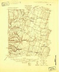 1924 Temple 3-B1924 Print · USGSBell County agriculture and rural life are captured in the mid-1920s as small communities thrived along the Leon River. Genealogists can trace early homesteads near the Whitehall School, Moffat, and the Hopewell Church.
 - 1931 Map of Belton, 1949 Print
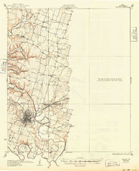 1931 Belton1949 Print · USGSBell County in the 1920s and 30s reveals a landscape of river-valley farming and bustling railroad junctions centered on the county seat. Genealogists and historians can trace early community life through numerous rural landmarks like Moffat Sch, Tennessee Valley Ch, and the Belton and Temple Electric R R.
 - 1954 Map of Waco, 1964 Print
 1954 Waco1964 Print · USGSCentral Texas during the mid-fifties shows a landscape defined by the expansion of Fort Hood Military Reservation and the Brazos river system. Trace the rail lines and early airfields like James Connally Air Force Base and settlements like Temple or McGregor.2 unique versions available
 - 1955 Map of Waco
 1955 Waco1955 Print · USGSCentral Texas at the peak of the Cold War reveals a landscape defined by military expansion and major water projects. Researchers can trace the footprints of Fort Hood, the waters of Lake Waco, and regional hubs like Temple or Mexia.
 - 1965 Map of Moffat, 1968 Print
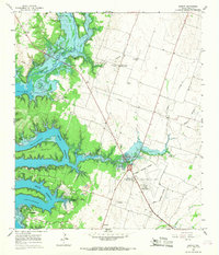 1965 Moffat1968 Print · USGSBell County was undergoing a major transformation in the mid-sixties as the Leon River valley was reshaped by reservoir waters. Genealogists and local historians can trace the rural landscape through Moffat Sch, White Hall, and several local burial grounds like Moffat Cem.3 unique versions available
 - 1985 Map of Temple
 1985 Temple1985 Print · USGSCentral Texas in the mid-eighties shows a landscape of massive defense installations and deep-rooted farming communities. Genealogists and historians can trace the development of Temple and Gatesville, locate the Gatesville State School for Boys, or explore rural outposts like Zabcikville and Westphalia.2 unique versions available
End of results
Showing maps 1-6 of 6
Top cities near Moffat
- Killeen historical maps
- Temple historical maps
- Harker Heights historical maps
- Belton historical maps
- Nolanville historical maps
- McGregor historical maps
See more
Frequently asked questions
- What are the different types of historical maps available for Moffat?
- What is the oldest map of Moffat?
- Where can I purchase historical maps of Moffat for my home or office?
- Where can I download high-res historical maps of Moffat?
- Are there historical topographic maps available for Moffat?
- Is there historical aerial imagery available for Moffat?
- Where are historical maps of Moffat sourced from?