1990s Maps of Leon Valley, Texas
Explore 5 historic maps of Leon Valley from the 1990s. These maps offer a rare glimpse into what life looked like during the 1990s — showing old roads, neighborhoods, homes, and landmarks that have changed or disappeared over time.
Whether you're researching your family's past, planning a metal detecting trip, or studying how Leon Valley's landscape evolved across the 1990s, these high-resolution maps are a powerful tool for exploring the history of this region.
- Focus on a specific era: All maps on this page are from the 1990s, giving you a focused view of this time period.
- See what’s changed: Compare century-old streets, trails, and buildings to today's modern landscape using overlays and satellite layers.
- Research with precision: Use these maps for genealogy, historical research, land use analysis, or educational projects.
- View, download, or print: Maps are fully viewable online in high resolution, and can be downloaded or printed for your own records.
Start exploring Leon Valley's history through authentic maps from the 1990s. This is your window into the past.
Leon Valley, TX maps
(5)- 1992 Map of New Braunfels
 1992 New Braunfels1992 Print · USGSThe San Antonio and New Braunfels corridor was expanding rapidly in the early nineties, balancing heavy military presence with Hill Country recreation. Trace the footprint of CAMP BULLIS MILITARY RESERVATION or locate old railroad stops along the Southern Pacific and Missouri Pacific lines.2 unique versions available
 - 1992 Map of Helotes
 1992 Helotes1992 Print · USGSBexar County experiences rapid suburban transformation in the early nineties as San Antonio expands toward the Hill Country. Genealogists and local historians can trace legacy burial sites like Menchaca Cem and Media Cem or the growth around the University of Texas at San Antonio.2 unique versions available
 - 1992 Map of Castle Hills, 1993 Print
 1992 Castle Hills1993 Print · USGSNorthern Bexar County in the early nineties shows a landscape of rapid suburban growth and institutional expansion. Genealogists and historians can trace neighborhood development alongside local landmarks like Locke Hill Sch, St Francis Ch, and the Olga Site.2 unique versions available
 - 1993 Map of Culebra Hill
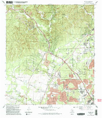
 1993 Culebra Hill1993 Print · USGSWestern Bexar County sees rapid suburban and military expansion during the early nineties. Genealogists and historians can trace the development of Lackland City and Leon Valley or locate the Sociedad Cem and Culebra Hill.2 unique versions available
 - 1993 Map of San Antonio West
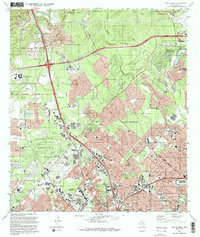
 1993 San Antonio West1993 Print · USGSThe western expansion of the city in the early nineties reveals a landscape defined by military aviation and dense community institutions. Trace the heritage of prominent sites like Our Lady of the Lake University, Lackland Air Force Base, and the historic San Fernando Cem No 2.
End of results
Showing maps 1-5 of 5
Top cities near Leon Valley
- San Antonio historical maps
- Kirby historical maps
- Helotes historical maps
- Alamo Heights historical maps
- Fair Oaks Ranch historical maps
- Windcrest historical maps
See more
Frequently asked questions
- What are the different types of historical maps available for Leon Valley?
- What is the oldest map of Leon Valley?
- Where can I purchase historical maps of Leon Valley for my home or office?
- Where can I download high-res historical maps of Leon Valley?
- Are there historical topographic maps available for Leon Valley?
- Is there historical aerial imagery available for Leon Valley?
- Where are historical maps of Leon Valley sourced from?