1950s Maps of Iredell, Texas
Explore 5 historic maps of Iredell from the 1950s. These maps offer a rare glimpse into what life looked like during the 1950s — showing old roads, neighborhoods, homes, and landmarks that have changed or disappeared over time.
Whether you're researching your family's past, planning a metal detecting trip, or studying how Iredell's landscape evolved across the 1950s, these high-resolution maps are a powerful tool for exploring the history of this region.
- Focus on a specific era: All maps on this page are from the 1950s, giving you a focused view of this time period.
- See what’s changed: Compare century-old streets, trails, and buildings to today's modern landscape using overlays and satellite layers.
- Research with precision: Use these maps for genealogy, historical research, land use analysis, or educational projects.
- View, download, or print: Maps are fully viewable online in high resolution, and can be downloaded or printed for your own records.
Start exploring Iredell's history through authentic maps from the 1950s. This is your window into the past.
Iredell, TX maps
(5)- 1954 Map of Waco, 1964 Print
 1954 Waco1964 Print · USGSCentral Texas during the mid-fifties shows a landscape defined by the expansion of Fort Hood Military Reservation and the Brazos river system. Trace the rail lines and early airfields like James Connally Air Force Base and settlements like Temple or McGregor.2 unique versions available
 - 1955 Map of Waco
 1955 Waco1955 Print · USGSCentral Texas at the peak of the Cold War reveals a landscape defined by military expansion and major water projects. Researchers can trace the footprints of Fort Hood, the waters of Lake Waco, and regional hubs like Temple or Mexia.
 - 1956 Map of Spring Creek Gap, 1957 Print
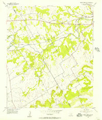 1956 Spring Creek Gap1957 Print · USGSCrossing the Bosque River valley in the mid-1950s, this area of Central Texas shows a landscape of rail-connected settlements and family cemeteries. Genealogists can trace local heritage at Iredell, Stanley Graves, and rural landmarks like Barbee Cem.2 unique versions available
 - 1956 Map of Iredell, 1957 Print
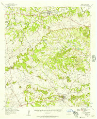 1956 Iredell1957 Print · USGSThe Bosque County hills in the mid-fifties were defined by small-town railroad hubs and a patchwork of family-owned ranch land. Genealogists can trace rural landmarks from The Rock Ch and Roberts School to the Missouri Kansas Texas line through Iredell.
 - 1956 Map of Iredell, 1957 Print
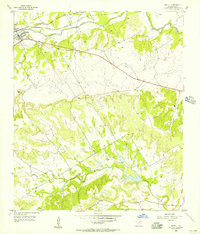 1956 Iredell1957 Print · USGSIredell and the surrounding Bosque County countryside are captured here in the mid-1950s as a quiet rail-and-river community. Genealogists and local historians can trace family roots at the New Iredell Cem, locate the Spring Creek Ch, or follow the path of the Missouri Kansas Texas railroad.2 unique versions available
End of results
Showing maps 1-5 of 5
Top cities near Iredell
- Meridian historical maps
- Hico historical maps
- Walnut Springs historical maps
- Cranfills Gap historical maps
Frequently asked questions
- What are the different types of historical maps available for Iredell?
- What is the oldest map of Iredell?
- Where can I purchase historical maps of Iredell for my home or office?
- Where can I download high-res historical maps of Iredell?
- Are there historical topographic maps available for Iredell?
- Is there historical aerial imagery available for Iredell?
- Where are historical maps of Iredell sourced from?