1950s Maps of Bowie County, Texas
Explore 28 historic maps of Bowie County from the 1950s. These maps offer a rare glimpse into what life looked like during the 1950s — showing old roads, neighborhoods, homes, and landmarks that have changed or disappeared over time.
Whether you're researching your family's past, planning a metal detecting trip, or studying how Bowie County's landscape evolved across the 1950s, these high-resolution maps are a powerful tool for exploring the history of this region.
- Focus on a specific era: All maps on this page are from the 1950s, giving you a focused view of this time period.
- See what’s changed: Compare century-old streets, trails, and buildings to today's modern landscape using overlays and satellite layers.
- Research with precision: Use these maps for genealogy, historical research, land use analysis, or educational projects.
- View, download, or print: Maps are fully viewable online in high resolution, and can be downloaded or printed for your own records.
Start exploring Bowie County's history through authentic maps from the 1950s. This is your window into the past.
Bowie County, TX maps
(28)- 1950 Map of Redbank, 1954 Print
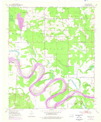
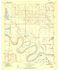
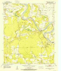
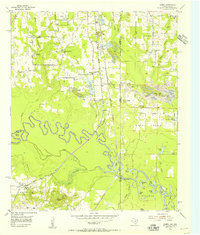
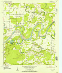 1950 Redbank1954 Print · USGSBowie County and the Arkansas border are defined by the winding Red River in the early fifties, showing a rural landscape of oxbow lakes and timbered bottoms. Researchers can trace local landmarks like Elizabeth Academy Ch, the Rifle Range (Abandoned), and Hughes Cem.3 unique versions available
 - 1950 Map of Ogden, 1966 Print
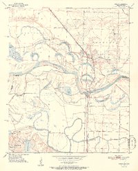
 1950 Ogden1966 Print · USGSThe riverlands of Southwest Arkansas are captured here in the mid-century, where the Red River meanders through a landscape of oxbow lakes and bayous. Researchers can trace the heritage of local communities through named schools and churches like Rosenwald Sch, Summer Hill Ch, and the settlement of Ogden.4 unique versions available
 - 1950 Map of De Kalb NW, 1969 Print
 1950 De Kalb NW1969 Print · USGSThe Red River valley at the Texas-Oklahoma border comes alive here during the mid-century, showing a landscape shaped by shifting waters and rural settlement. Researchers can trace family roots through sites like Harris Cem, Antioch Ch, and the many local schoolhouses like Field Ridge Sch.2 unique versions available
 - 1950 Map of Barkman, 1969 Print
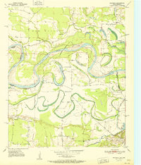
 1950 Barkman1969 Print · USGSThe Texas-Arkansas borderlands are captured here at mid-century, where the Red River's shifting path created a rich landscape of oxbow lakes and bayous. Genealogists can trace rural life through landmarks like Rosenwald Sch, Barkman, and the Clear Lake Cem.5 unique versions available
 - 1950 Map of Tom, 1976 Print
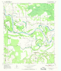
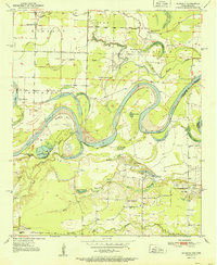
 1950 Tom1976 Print · USGSMcCurtain County sits along the winding Red River at the Texas border in the mid-twentieth century. Family historians can trace local roots through numerous country schools like Pecan Grove Sch and Oak Ridge Sch, or explore the river's path around Severn Island.
 - 1950 Map of De Kalb, 1976 Print
 1950 De Kalb1976 Print · USGSBowie County at mid-century shows a landscape of rural schools and family cemeteries clustered around the De Kalb rail corridor. Genealogists can trace local landmarks like Woodman Cem, Bethlehem Sch, and the banks of the Red River.2 unique versions available
 - 1950 Map of Oak Grove, 1976 Print
 1950 Oak Grove1976 Print · USGSBowie County at the midpoint of the century shows a landscape of small rail-side communities and scattered country parishes. Genealogists can trace family footprints near Oak Grove, Garland, and rural landmarks like Gravel Hill Ch or the Garland Cem.
 - 1951 Map of De Kalb
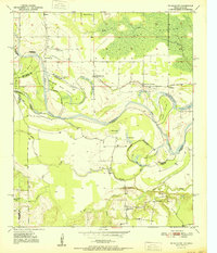
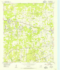
 1951 De Kalb1951 Print · USGSBowie County, Texas, was a landscape of small schools and rural churches in the years following the war. Researchers can trace the Texas and Pacific rail line through De Kalb or locate family markers at Woodman Cem and Harrell Cem.
 - 1951 Map of De Kalb NW
 1951 De Kalb NW1951 Print · USGSThe Red River valley at the Oklahoma-Texas border is captured here in the early fifties, showing a landscape shaped by shifting river bends. Genealogists and local historians can trace the locations of Riverside Sch, Antioch Ch, and family landmarks like Jim Jones Hill.
 - 1951 Map of Tom
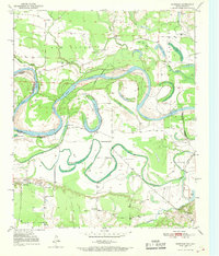
 1951 Tom1951 Print · USGSSoutheast Oklahoma and Northeast Texas meet along the winding river valley during the early fifties, showing a rural landscape of scattered schools and family cemeteries. Genealogists can locate Harris Cem and Pine Ridge Sch or trace the route of the Clear Lake Ferry.2 unique versions available
 - 1951 Map of Oak Grove
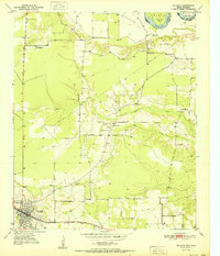
 1951 Oak Grove1951 Print · USGSBowie County at the dawn of the 1950s shows a landscape of rural communities tied together by the Texas and Pacific rail line. Genealogists can trace family footprints at Mt Pleasant Sch, Garland Cem, and West Bowie Union Ch.
 - 1951 Map of Redbank
 1951 Redbank1951 Print · USGSThe Red River valley in the early fifties shows a landscape of oxbow lakes and rural settlements straddling the Texas-Arkansas line. Genealogists can locate family landmarks like Elizabeth Academy Ch, the Redbank community, and the Vocational School.
 - 1951 Map of Ogden
 1951 Ogden1951 Print · USGSThe Red River borderlands of Arkansas and Texas come alive in this mid-century survey, showcasing a landscape of shifting oxbows and rural crossings. Researchers can trace local heritage through the Rosenwald Sch, St Johns Ch, and the rail stop at Ogden.2 unique versions available
 - 1951 Map of Barkman
 1951 Barkman1951 Print · USGSBowie County, Texas, and the Arkansas borderlands are captured here in the early fifties, dominated by the serpentine coils of the Red River. Researchers can locate family landmarks like the Rosenwald Sch, Clear Lake Cem, and the riverfront settlement of Barkman.
 - 1951 Map of Foreman, 1952 Print
 1951 Foreman1952 Print · USGSThe Arkansas-Oklahoma-Texas borderlands are captured here in the early fifties, where the Red River and St Louis San Francisco rail line shaped local commerce. Genealogists can locate family landmarks like Sand Hill Cem, Matteson Gin, and Lanesport.5 unique versions available
 - 1951 Map of Daniels Chapel, 1952 Print
 1951 Daniels Chapel1952 Print · USGSThe Red River valley at the Texas and Arkansas border is shown here in the early fifties, capturing a landscape of shifting river islands and rural settlements. Genealogists can trace family landmarks like Spring Branch Cem, Daniels Chapel, and Lewis Ferry.4 unique versions available
 - 1953 Map of Texarkana, 1964 Print
 1953 Texarkana1964 Print · USGSThe Texas-Arkansas borderlands are captured here in the mid-fifties, during a decade of massive military and hydraulic engineering projects. Genealogists and researchers can locate family landmarks like Old Boston Cem, Siloam Ch, and the vast Red River Arsenal.4 unique versions available
 - 1954 Map of New Boston, 1955 Print
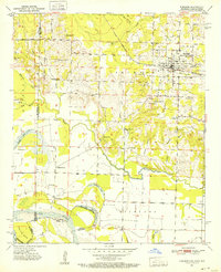
 1954 New Boston1955 Print · USGSNew Boston and the Red River Arsenal area are captured here in the mid-fifties, showing the intersection of military expansion and rural life. Trace the former county seat at Boston, the Bowie County Courthouse, and old sites like Antioch Ch.4 unique versions available
 - 1954 Map of Texarkana, 1955 Print
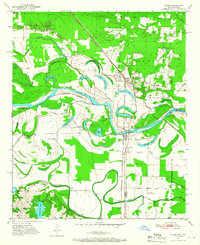
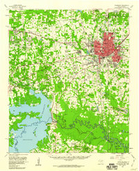
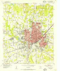 1954 Texarkana1955 Print · USGSTexarkana straddles the state line in the mid-fifties, serving as a primary crossroads for four major railroad lines. Genealogists and local historians can trace the foundations of the city through sites like the Railway Hospital, Holy Cross Cem, and Texarkana Junior College.6 unique versions available
 - 1954 Map of Domino, 1955 Print
 1954 Domino1955 Print · USGSCrossing the Texas and Arkansas border in the mid-fifties, this area shows a landscape defined by the winding Sulphur River and active gravel mining. Genealogists can locate rural landmarks like Buchanan Cem, Bright Star Ch, and the settlement of Domino.5 unique versions available
 - 1954 Map of Leary, 1955 Print
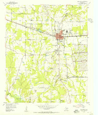
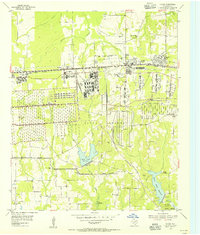
 1954 Leary1955 Print · USGSBowie County in the mid-fifties is defined by the intersection of military industrialization and rural Texas life. Researchers can trace the sprawling Red River Arsenal grounds or locate local landmarks like Macedonia School, Victory City, and the Redwater Lookout Tower.4 unique versions available
 - 1954 Map of Hooks, 1955 Print
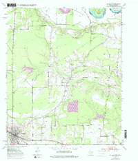
 1954 Hooks1955 Print · USGSBowie County in the mid-fifties is defined by the massive infrastructure of the Red River Arsenal and its vital rail connections. Genealogists and historians can trace numerous family landmarks like the Elliott Plot or McAdams Cem and find early rural schools including Arkadelphia Sch.3 unique versions available
 - 1954 Map of Lake Texarkana, 1955 Print
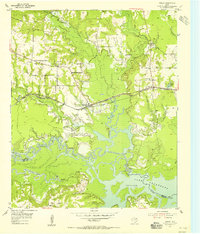
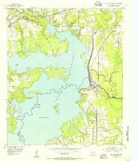 1954 Lake Texarkana1955 Print · USGSNortheast Texas is captured here in the mid-fifties during the transformation of the Sulphur River valley. Genealogists and historians can locate rural landmarks like Opossum Trot Church, the Holloway Cem, and the crossing at McCartney Bridge.6 unique versions available
 - 1954 Map of Texarkana, 1960 Print
 1954 Texarkana1960 Print · USGSTexarkana and its surrounding borderlands are captured at a mid-century peak of industrial and suburban growth. Genealogists and historians can trace the foundations of Wake Village, locate the Red River Arsenal, and find rural landmarks like Hampton Chapel and Red Springs Cem.2 unique versions available
 - 1955 Map of Corley
 1955 Corley1955 Print · USGSBowie County rural life in the mid-fifties is captured here as a new road network begins to take shape. Researchers can locate family landmarks such as Old Union Cem, Mount Obie Ch, and the small settlement of Carbondale.3 unique versions available
Showing maps 1-25 of 28
Top cities of Bowie County
- Texarkana historical maps
- Wake Village historical maps
- New Boston historical maps
- Nash historical maps
- Hooks historical maps
- De Kalb historical maps
See more
Frequently asked questions
- What are the different types of historical maps available for Bowie County?
- What is the oldest map of Bowie County?
- Where can I purchase historical maps of Bowie County for my home or office?
- Where can I download high-res historical maps of Bowie County?
- Are there historical topographic maps available for Bowie County?
- Is there historical aerial imagery available for Bowie County?
- Where are historical maps of Bowie County sourced from?