1980s Maps of Loy Place, Texas
Explore 2 historic maps of Loy Place from the 1980s. These maps offer a rare glimpse into what life looked like during the 1980s — showing old roads, neighborhoods, homes, and landmarks that have changed or disappeared over time.
Whether you're researching your family's past, planning a metal detecting trip, or studying how Loy Place's landscape evolved across the 1980s, these high-resolution maps are a powerful tool for exploring the history of this region.
- Focus on a specific era: All maps on this page are from the 1980s, giving you a focused view of this time period.
- See what’s changed: Compare century-old streets, trails, and buildings to today's modern landscape using overlays and satellite layers.
- Research with precision: Use these maps for genealogy, historical research, land use analysis, or educational projects.
- View, download, or print: Maps are fully viewable online in high resolution, and can be downloaded or printed for your own records.
Start exploring Loy Place's history through authentic maps from the 1980s. This is your window into the past.
Loy Place, TX maps
(2)- 1983 Map of Straddlebug Mountain, 1984 Print
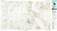
 1983 Straddlebug Mountain1984 Print · USGSBrewster County ranching life is well-documented in the early eighties, showing a landscape of wide-open valleys and isolated homesteads. Researchers can locate the expansive O2 Ranch, find historical Landing Strips, and trace the path of Terlingua Creek through the desert.
 - 1985 Map of Santiago Mountains, 1994 Print
 1985 Santiago Mountains1994 Print · USGSThe Trans-Pecos region of West Texas in the mid-1980s reveals a vast network of isolated ranching outposts and protected wildlands. Genealogists and historians can trace old homesteads near Butcherknife and Cochran or locate landmarks like Santiago Peak and Nine Point Mesa.2 unique versions available
End of results
Showing maps 1-2 of 2
Frequently asked questions
- What are the different types of historical maps available for Loy Place?
- What is the oldest map of Loy Place?
- Where can I purchase historical maps of Loy Place for my home or office?
- Where can I download high-res historical maps of Loy Place?
- Are there historical topographic maps available for Loy Place?
- Is there historical aerial imagery available for Loy Place?
- Where are historical maps of Loy Place sourced from?