1900s (20th Century) Maps of Thrifty, Texas
Explore 5 historic maps of Thrifty from the 1900s (20th Century). These maps offer a rare glimpse into what life looked like during the 1900s — showing old roads, neighborhoods, homes, and landmarks that have changed or disappeared over time.
Whether you're researching your family's past, planning a metal detecting trip, or studying how Thrifty's landscape evolved across the 1900s, these high-resolution maps are a powerful tool for exploring the history of this region.
- Focus on a specific era: All maps on this page are from the 1900s, giving you a focused view of this time period.
- See what’s changed: Compare century-old streets, trails, and buildings to today's modern landscape using overlays and satellite layers.
- Research with precision: Use these maps for genealogy, historical research, land use analysis, or educational projects.
- View, download, or print: Maps are fully viewable online in high resolution, and can be downloaded or printed for your own records.
Start exploring Thrifty's history through authentic maps from the 1900s. This is your window into the past.
Thrifty, TX maps
(5)- 1924 Map of Brownwood Reservoir Site
 1924 Brownwood Reservoir Site1924 Print · USGSThe river valleys of Brown County are captured here in the mid-1920s during the planning of a major reservoir project. Researchers can trace the original landscape of Pecan Bayou and locate vanished landmarks like Rocky Church and Frys Ford before the waters rose.
 - 1927 Map of Grosvenor
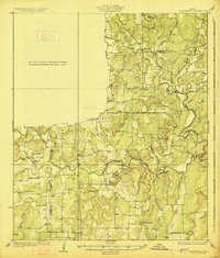 1927 Grosvenor1927 Print · USGSIn the mid-1920s, the rural landscapes of Brown and Coleman Counties were connected by winding wagon roads and creek fords. Genealogists can trace the early community hubs of Grosvenor and Thrifty alongside schools like Macedonia School and Buffalo School.2 unique versions available
 - 1954 Map of Brownwood, 1955 Print
 1954 Brownwood1955 Print · USGSCentral Texas in the early fifties shows a landscape of rail-linked cattle towns and winding river valleys before modern highway expansion. Genealogists and historians can trace family-named peaks and vanished rail stops like Trickham, Santa Anna, and the Brady Mountains.3 unique versions available
 - 1969 Map of Thrifty, 1972 Print
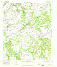 1969 Thrifty1972 Print · USGSThe ranching and oil lands of Brown County are captured in the late sixties as the rural landscape underwent modern industrial shifts. Genealogists and historians can trace family locations near Eureka Ch, Salem Cem, and the settlement of Thrifty.
 - 1985 Map of Coleman
 1985 Coleman1985 Print · USGSCentral Texas ranching and rail country comes to life in the 1980s as the Atchison Topeka and Santa Fe line cuts through Coleman. Researchers can trace old settlements and topography from Robinson Peak to the waters of Lake Brownwood State Park.2 unique versions available
End of results
Showing maps 1-5 of 5
Top cities near Thrifty
Frequently asked questions
- What are the different types of historical maps available for Thrifty?
- What is the oldest map of Thrifty?
- Where can I purchase historical maps of Thrifty for my home or office?
- Where can I download high-res historical maps of Thrifty?
- Are there historical topographic maps available for Thrifty?
- Is there historical aerial imagery available for Thrifty?
- Where are historical maps of Thrifty sourced from?