1960s Maps of Bertram, Texas
Explore 2 historic maps of Bertram from the 1960s. These maps offer a rare glimpse into what life looked like during the 1960s — showing old roads, neighborhoods, homes, and landmarks that have changed or disappeared over time.
Whether you're researching your family's past, planning a metal detecting trip, or studying how Bertram's landscape evolved across the 1960s, these high-resolution maps are a powerful tool for exploring the history of this region.
- Focus on a specific era: All maps on this page are from the 1960s, giving you a focused view of this time period.
- See what’s changed: Compare century-old streets, trails, and buildings to today's modern landscape using overlays and satellite layers.
- Research with precision: Use these maps for genealogy, historical research, land use analysis, or educational projects.
- View, download, or print: Maps are fully viewable online in high resolution, and can be downloaded or printed for your own records.
Start exploring Bertram's history through authentic maps from the 1960s. This is your window into the past.
Bertram, TX maps
(2)- 1967 Map of Joppa, 1969 Print
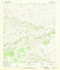 1967 Joppa1969 Print · USGSTexas hill country life comes into focus in the late sixties as small communities like Joppa and Shady Grove thrive along the San Gabriel forks. Researchers can find ancestral landmarks like Strickling Cem, the Blacks Fort ruins, and the Price Landing Strip.
 - 1967 Map of Bertram, 1970 Print
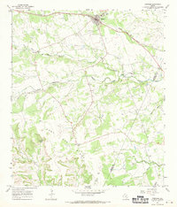 1967 Bertram1970 Print · USGSBertram thrived as a railroad and quarrying hub in the Texas Hill Country during the late sixties. Genealogists and local researchers can trace old family burial grounds like South Gabriel Cem or locate rural landmarks such as Mt Zion Ch and Buzzard Roost.2 unique versions available
End of results
Showing maps 1-2 of 2
Top cities near Bertram
- Cedar Park historical maps
- Leander historical maps
- Liberty Hill historical maps
- Marble Falls historical maps
- Burnet historical maps
- Jonestown historical maps
See more
Frequently asked questions
- What are the different types of historical maps available for Bertram?
- What is the oldest map of Bertram?
- Where can I purchase historical maps of Bertram for my home or office?
- Where can I download high-res historical maps of Bertram?
- Are there historical topographic maps available for Bertram?
- Is there historical aerial imagery available for Bertram?
- Where are historical maps of Bertram sourced from?