Old Maps of Calhoun County, Texas
Explore 69 old maps of Calhoun County, spanning from 1950 to today. These high-resolution historic maps reveal how streets, neighborhoods, landmarks, and natural features evolved over time — perfect for genealogy, metal detecting, research, and local history exploration.
What you can do with these maps:
- See how Calhoun County changed over time: Compare historical maps to modern-day views to trace roads, homesites, rail lines & more.
- View detailed metadata: Each map includes creators, publishers, year, scale, and archive source.
- Overlay maps with satellite & LiDAR: Visualize the past alongside modern tools to explore terrain & human change.
- Trusted historical sources: Maps sourced from the USGS, Library of Congress, and other archives.
- Access maps your way: View online, download high-res files, or order prints for personal or research use.
Start exploring old maps of Calhoun County to uncover forgotten places, hidden landmarks, and the deep history beneath your feet.
Calhoun County, TX maps
(69)- 1950 Map of Corpus Christi, 1953 Print
 1950 Corpus Christi1953 Print · USGSThe South Texas coast comes into focus during the early fifties, showing the interplay between booming oil fields and expansive ranching operations. Genealogists and historians can trace the Texas Mexican rail line through Kingsville or locate heritage sites like Chapman Ranch and Riviera Beach.
 - 1951 Map of Keller Bay, 1953 Print
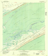
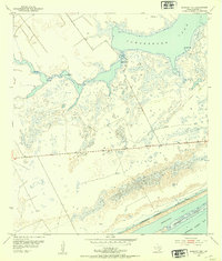
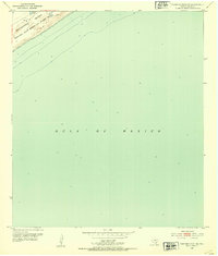
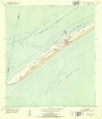
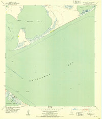 1951 Keller Bay1953 Print · USGSThe Calhoun County coastline in the early fifties shows a landscape of shallow estuaries and maritime hazards. Researchers can trace the shifting sands of Indianola Island and locate specific sites like a Sunken Wreck or the coastal Landing Field.4 unique versions available
 - 1952 Map of Port Lavaca East, 1953 Print
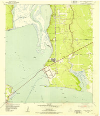
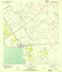
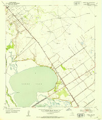
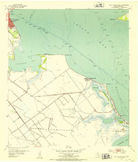 1952 Port Lavaca East1953 Print · USGSThe Texas Gulf Coast comes into focus in the early fifties, showing the working waterfronts and small beach communities of Calhoun County. Genealogists and historians can locate the Indianola Cem, the old Wilkins Sch, and landmarks like Magnolia Beach.4 unique versions available
 - 1952 Map of Mosquito Point, 1953 Print
 1952 Mosquito Point1953 Print · USGSThe Texas Gulf Coast comes to life in this mid-century survey of Calhoun County, where military training grounds and energy extraction meet the sea. Trace the early oil and gas industry near Mosquito Point or explore the extensive Matagorda Island Bombing and Gunnery Range.3 unique versions available
 - 1952 Map of Pass Cavallo SW, 1953 Print
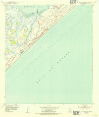
 1952 Pass Cavallo SW1953 Print · USGSMatagorda Island was a pivotal military site during the early Cold War, serving as a strategic barrier between the Gulf and the bay. Researchers can trace the layout of the Matagorda Island Air Force Base, the U S Coast Guard Station, and the sprawling Bombing and Gunnery Range.2 unique versions available
 - 1952 Map of Point Comfort, 1953 Print
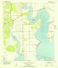
 1952 Point Comfort1953 Print · USGSExperience the Texas coast in the early fifties as the industrial footprint at Point Comfort expanded alongside the Lavaca River. Local researchers can trace the oil wells of Lake Field and maritime landmarks like Gallinipper Reef.4 unique versions available
 - 1952 Map of Long Island, 1953 Print
 1952 Long Island1953 Print · USGSThe Calhoun County coast in the early fifties shows a landscape defined by military training and complex tidal geography. Researchers can trace the bounds of the Matagorda Island Bombing and Gunnery Range and locate landmarks like Josephine Reef and Rahal Bayou.4 unique versions available
 - 1952 Map of Tivoli, 1953 Print
 1952 Tivoli1953 Print · USGSCoastal prairie life in Refugio County during the early fifties revolved around the railroad and river systems. Genealogists and local historians can trace the development of Tivoli and Maudlowe, alongside ranching landmarks like Red Mill Tank and Anaqua Tank.3 unique versions available
 - 1952 Map of Bloomington SW, 1953 Print
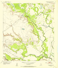 1952 Bloomington SW1953 Print · USGSThe lower reaches of the Guadalupe and San Antonio rivers met in the early fifties amidst a growing coastal oil economy. Trace family landmarks like Rudolph Cem or follow the Missouri Pacific railroad as it crosses Cushman Bayou.4 unique versions available
 - 1952 Map of Olivia, 1953 Print
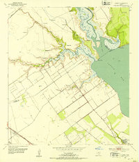
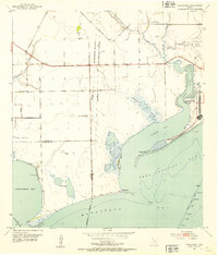
 1952 Olivia1953 Print · USGSCoastal Calhoun and Jackson counties are captured in the early fifties as these bayfront communities thrived on the Gulf. Genealogists and historians can trace the foundations of Olivia, find the Olivia Eden Ch, and locate old landmarks like Port Alto and Weedhaven.2 unique versions available
 - 1952 Map of Mesquite Bay, 1953 Print
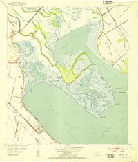
 1952 Mesquite Bay1953 Print · USGSCoastal Texas in the early fifties is defined here by the wild wetlands of the Aransas National Wildlife Refuge and its surrounding bays. You can trace the complex network of barrier islands and inlets, from the Second Chain of Islands to family-named landmarks like Carlos Windmills.4 unique versions available
 - 1952 Map of Tivoli SE, 1953 Print
 1952 Tivoli SE1953 Print · USGSThe Blackjack Peninsula and its coastal marshes are captured in the early fifties, shortly after the establishment of the wildlife refuge. Researchers can find old ranching landmarks like Buzzard Windmill and follow the shoreline from Webb Point to Mustang L.2 unique versions available
 - 1952 Map of Kamey, 1953 Print
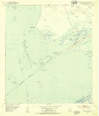
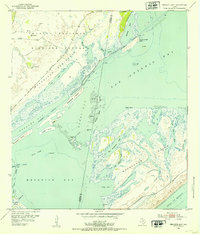
 1952 Kamey1953 Print · USGSAlong the edges of Lavaca Bay in the early fifties, the coastal prairie was a landscape of tide-water marshes and rising energy infrastructure. Researchers can trace the Southern Pacific rail line to Kamey or locate Sixmile Sch and dozens of flowing wells.3 unique versions available
 - 1952 Map of Seadrift NE, 1953 Print
 1952 Seadrift NE1953 Print · USGSCoastal Calhoun County in the early fifties shows a landscape of tidal marshes and emerging industry. Trace early petroleum infrastructure like the Pipe Line and Oil Wells alongside the waters of Powderhorn Lake and Dewberry Island.2 unique versions available
 - 1952 Map of Panther Point, 1953 Print
 1952 Panther Point1953 Print · USGSMatagorda Island in the early fifties shows the intersection of military training and coastal geography. Researchers can trace the extent of the Matagorda Island Bombing and Gunnery Range and find landmarks like Panther Point and Cedar Point.3 unique versions available
 - 1952 Map of Turtle Bay, 1953 Print
 1952 Turtle Bay1953 Print · USGSThe Matagorda County coastline during the early fifties reveals a landscape of coastal defenses and aviation infrastructure. Researchers can locate Camp Hulen, the Palacios Municipal Airport, and rural landmarks like Carancahua Ch.3 unique versions available
 - 1952 Map of Austwell, 1953 Print
 1952 Austwell1953 Print · USGSThe Texas Gulf Coast near the Refugio and Calhoun county line is captured here in the early fifties, showing a land defined by water and rail. Trace the railhead at Austwell, locate the Austwell Cem, and explore the marshes of Mission Lake.3 unique versions available
 - 1952 Map of Seadrift, 1953 Print
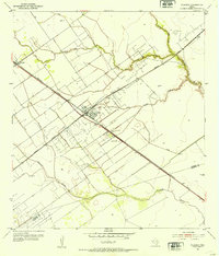
 1952 Seadrift1953 Print · USGSSeadrift and the Calhoun County coast come alive in the early 1950s as the local economy shifts toward the Long Mott Oil Field. Researchers can trace the legacy of the Missouri Pacific rail line and locate the Stienberg Cem or Roemerville Sch.2 unique versions available
 - 1952 Map of Port Lavaca West, 1953 Print
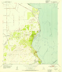
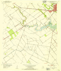 1952 Port Lavaca West1953 Print · USGSCoastal Texas at mid-century shows the intersection of industry and the gulf at Port Lavaca and Chocolate Bay. Researchers can locate family landmarks like Branch Cem, trace the Southern Pacific rail line, or find the old Tanner Airport.2 unique versions available
 - 1952 Map of Placedo, 1953 Print
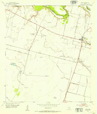
 1952 Placedo1953 Print · USGSThe Texas coastal plain near Victoria emerges as a center for oil and rail in the early fifties. Genealogists and researchers can trace the industrial footprint of Placedo Field and find historic sites in Placedo, Dacosta, and Carr.2 unique versions available
 - 1952 Map of Panther Point NE, 1953 Print
 1952 Panther Point NE1953 Print · USGSMatagorda Island was defined by its dual role as a coastal ranch and military training site during the early fifties. Researchers can trace the footprint of the Matagorda Island Bombing and Gunnery Range and find landmarks like Power Lake and a lone Windmill.3 unique versions available
 - 1952 Map of Decros Point, 1953 Print
 1952 Decros Point1953 Print · USGSThe Texas coastline in the early fifties reveals the specialized development of the Matagorda Peninsula and its maritime channels. Researchers can trace the layout of the Matagorda Club, the local Matagorda Club Airport, and several artesian Flowing Wells among the dunes.3 unique versions available
 - 1952 Map of Green Lake, 1953 Print
 1952 Green Lake1953 Print · USGSThe Texas Gulf Coast comes to life in the early fifties, showing a landscape shaped by petroleum and coastal wetlands. Researchers can trace the Heyser Oil Field and the Missouri Pacific rail line through Heyser and Green Lake.2 unique versions available
 - 1952 Map of St. Charles Bay SE, 1954 Print
 1952 St. Charles Bay SE1954 Print · USGSThe Aransas and Calhoun county coastlines appear in the early fifties, capturing a wild landscape of barrier islands and tidal flats. Trace ranching and early energy footprints through the Wynne Ranch, the Oil Well, and numerous Windmills.4 unique versions available
 - 1952 Map of Port O'Connor, 1954 Print
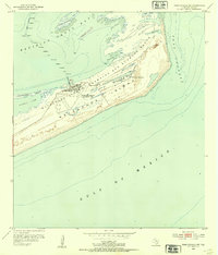
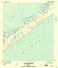
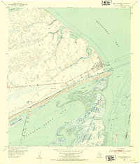 1952 Port O'Connor1954 Print · USGSThe Texas Gulf Coast comes to life in the early fifties as Port O'Connor anchors a landscape of barrier islands and military ranges. Trace coastal heritage through the U S Coast Guard Station, Submerged Ruins, and the sprawling Matagorda Island Bombing and Gunnery Range.3 unique versions available
Showing maps 1-25 of 69
Top cities of Calhoun County
- Port Lavaca historical maps
- Seadrift historical maps
- Port O'Connor historical maps
- Point Comfort historical maps
Frequently asked questions
- What are the different types of historical maps available for Calhoun County?
- What is the oldest map of Calhoun County?
- Where can I purchase historical maps of Calhoun County for my home or office?
- Where can I download high-res historical maps of Calhoun County?
- Are there historical topographic maps available for Calhoun County?
- Is there historical aerial imagery available for Calhoun County?
- Where are historical maps of Calhoun County sourced from?