1990s Maps of Calhoun County, Texas
Explore 9 historic maps of Calhoun County from the 1990s. These maps offer a rare glimpse into what life looked like during the 1990s — showing old roads, neighborhoods, homes, and landmarks that have changed or disappeared over time.
Whether you're researching your family's past, planning a metal detecting trip, or studying how Calhoun County's landscape evolved across the 1990s, these high-resolution maps are a powerful tool for exploring the history of this region.
- Focus on a specific era: All maps on this page are from the 1990s, giving you a focused view of this time period.
- See what’s changed: Compare century-old streets, trails, and buildings to today's modern landscape using overlays and satellite layers.
- Research with precision: Use these maps for genealogy, historical research, land use analysis, or educational projects.
- View, download, or print: Maps are fully viewable online in high resolution, and can be downloaded or printed for your own records.
Start exploring Calhoun County's history through authentic maps from the 1990s. This is your window into the past.
Calhoun County, TX maps
(9)- 1995 Map of Placedo
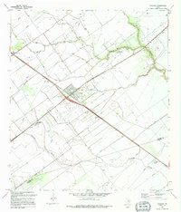 1995 Placedo1995 Print · USGSThe South Texas coastal plain comes into focus in the 1990s as a hub of energy production and rural community life. Researchers can trace the industrial footprint of the Heyser Oil and Gas Field alongside local landmarks like Placedo Brethren Ch and Bloomington High Sch.
 - 1995 Map of Olivia
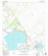
 1995 Olivia1995 Print · USGSThe Texas Gulf Coast near the Jackson and Calhoun county line is shown here in the mid-1990s. Genealogists and local historians can locate the Olivia Cem and small coastal communities like Olivia, Port Alto, and Cape Carancahua.
 - 1995 Map of Port Lavaca East
 1995 Port Lavaca East1995 Print · USGSCoastal Calhoun County in the mid-nineties shows the enduring legacy of early Texas settlements along the Gulf. Researchers can trace the proximity of the Historical Monument to Indianola Cem and the residential growth at Alamo Beach.
 - 1995 Map of Kamey
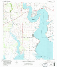
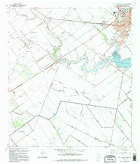
 1995 Kamey1995 Print · USGSThe Texas coast near Port Lavaca comes alive in this mid-nineties survey of the tidal wetlands and industrial infrastructure. Researchers can trace the layout of the Oil and Gas Field, locate the Sixmile Ch, and see the early development of Port Lavaca.
 - 1995 Map of Port Lavaca West
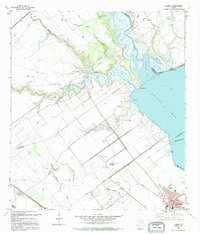
 1995 Port Lavaca West1995 Print · USGSCoastal Texas development meets the petroleum industry in the 1990s near the shores of Chocolate Bay. Trace the growth of Port Lavaca and its local landmarks, from Colonial Gardens Cem to the regional Tanner Airport.
 - 1995 Map of Turtle Bay
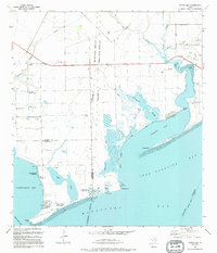 1995 Turtle Bay1995 Print · USGSThe Texas Gulf Coast near the Jackson and Matagorda county lines is captured here in the mid-nineties as aquaculture and coastal communities shaped the shore. Trace family footprints in the Schicke Point Community or study the marshes around Buttermilk Slough and Sartwelle Lakes.
 - 1995 Map of Green Lake
 1995 Green Lake1995 Print · USGSThe Texas coast near the Guadalupe River delta is shown here in the mid-1990s as a land of managed wetlands and energy production. Researchers can trace the industrial footprint of the Heyser Gas Field and the Old RR Grade alongside Green Lake.
 - 1995 Map of Point Comfort
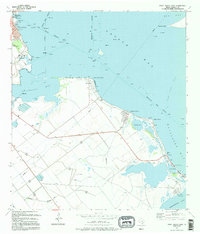
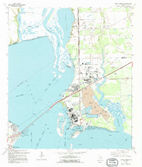 1995 Point Comfort1995 Print · USGSThe industrial heart of the Texas Gulf Coast is on display in the 1990s as processing plants and shipping channels define the shoreline. Researchers can trace the massive Chemical Plant complex and locate recreational landmarks like Lighthouse Beach and Noble Point.
 - 1995 Map of Bloomington SW
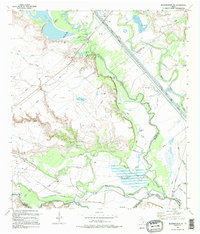 1995 Bloomington SW1995 Print · USGSCoastal Texas river bottoms and wetlands are mapped here in the mid-nineties as the industrial landscape meets the bayous. Genealogists and researchers can locate the Nolan Cem and Rudolph Cem among the bends of the Guadalupe River.
End of results
Showing maps 1-9 of 9
Top cities of Calhoun County
- Port Lavaca historical maps
- Seadrift historical maps
- Port O'Connor historical maps
- Point Comfort historical maps
Frequently asked questions
- What are the different types of historical maps available for Calhoun County?
- What is the oldest map of Calhoun County?
- Where can I purchase historical maps of Calhoun County for my home or office?
- Where can I download high-res historical maps of Calhoun County?
- Are there historical topographic maps available for Calhoun County?
- Is there historical aerial imagery available for Calhoun County?
- Where are historical maps of Calhoun County sourced from?