Old Maps of 21 Subdivision Colonia, Brownsville for Metal Detecting
Plan your next treasure hunt with 9 historic maps of 21 Subdivision Colonia. Find old homesites, ghost towns, trails, and gathering spots that may be lost to time — perfect for identifying promising metal detecting locations.
- Locate forgotten sites: Uncover places like long-lost settlements, abandoned rail lines, or gathering spots.
- Plan better hunts: Use map overlays combined with LiDAR or satellite views to narrow in on historically rich areas.
- Made for detectorists: Thousands of hobbyists use these maps to discover relics, coins, and hidden history.
Use these historic maps to boost your research and find new opportunities beneath the surface of 21 Subdivision Colonia.
21 Subdivision Colonia, Brownsville maps
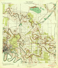
(9)- 1930 Map of East Brownsville
 1930 East Brownsville1930 Print · USGSCovers 21 Subdivision Colonia, including Brownsville, Cameron Park, and other nearby areas
 - 1936 Map of East Brownsville
 1936 East Brownsville1936 Print · USGSCovers 21 Subdivision Colonia, including Brownsville, Cameron Park, and other nearby areas3 unique versions available
 - 1953 Map of Brownsville
 1953 Brownsville1953 Print · USGSCovers 21 Subdivision Colonia, including Matamoros, Brownsville, and other nearby areas
 - 1955 Map of East Brownsville, 1957 Print
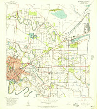 1955 East Brownsville1957 Print · USGSCovers 21 Subdivision Colonia, including Brownsville, Cameron Park, and other nearby areas6 unique versions available
 - 1955 Map of Fort Brown, 1958 Print
 1955 Fort Brown1958 Print · USGSCovers 21 Subdivision Colonia, including Brownsville, Cameron Park, and other nearby areas
 - 1956 Map of Brownsville, 1969 Print
 1956 Brownsville1969 Print · USGSCovers 21 Subdivision Colonia, including Matamoros, Brownsville, and other nearby areas2 unique versions available
 - 1962 Map of Brownsville
 1962 Brownsville1962 Print · USGSCovers 21 Subdivision Colonia, including Matamoros, Brownsville, and other nearby areas
 - 1992 Map of Brownsville
 1992 Brownsville1992 Print · USGSCovers 21 Subdivision Colonia, including Matamoros, Brownsville, and other nearby areas
 - 2022 Map of East Brownsville, 2022 Print
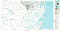
 2022 East Brownsville2022 Print · USGSCovers 21 Subdivision Colonia, including Brownsville, Cameron Park, and other nearby areas
End of results
Showing maps 1-9 of 9
Top cities near 21 Subdivision Colonia
- Brownsville historical maps
- Harlingen historical maps
- San Benito historical maps
- Cameron Park historical maps
- Los Fresnos historical maps
- Port Isabel historical maps
See more
Frequently asked questions
- What are the different types of historical maps available for 21 Subdivision Colonia?
- What is the oldest map of 21 Subdivision Colonia?
- Where can I purchase historical maps of 21 Subdivision Colonia for my home or office?
- Where can I download high-res historical maps of 21 Subdivision Colonia?
- Are there historical topographic maps available for 21 Subdivision Colonia?
- Is there historical aerial imagery available for 21 Subdivision Colonia?
- Where are historical maps of 21 Subdivision Colonia sourced from?