1930s Maps of Valle Hermosa Colonia, Texas
Explore 1 historic maps of Valle Hermosa Colonia from the 1930s. These maps offer a rare glimpse into what life looked like during the 1930s — showing old roads, neighborhoods, homes, and landmarks that have changed or disappeared over time.
Whether you're researching your family's past, planning a metal detecting trip, or studying how Valle Hermosa Colonia's landscape evolved across the 1930s, these high-resolution maps are a powerful tool for exploring the history of this region.
- Focus on a specific era: All maps on this page are from the 1930s, giving you a focused view of this time period.
- See what’s changed: Compare century-old streets, trails, and buildings to today's modern landscape using overlays and satellite layers.
- Research with precision: Use these maps for genealogy, historical research, land use analysis, or educational projects.
- View, download, or print: Maps are fully viewable online in high resolution, and can be downloaded or printed for your own records.
Start exploring Valle Hermosa Colonia's history through authentic maps from the 1930s. This is your window into the past.
Valle Hermosa Colonia, TX maps
(1)- 1936 Map of Southmost
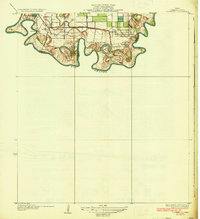 1936 Southmost1936 Print · USGSThe tip of South Texas meets the international boundary in the mid-1930s, showing a river-driven landscape of large agricultural holdings and early railroad spurs. Researchers can trace the heritage of the Rabb Plantation, locate the Palm Grove Sch, and see the original layouts of Southmost and Nogales Ranch.3 unique versions available
End of results
Showing maps 1-1 of 1
Top cities near Valle Hermosa Colonia
- Brownsville historical maps
- San Benito historical maps
- Cameron Park historical maps
- Los Fresnos historical maps
- Port Isabel historical maps
- Laguna Vista historical maps
See more
Frequently asked questions
- What are the different types of historical maps available for Valle Hermosa Colonia?
- What is the oldest map of Valle Hermosa Colonia?
- Where can I purchase historical maps of Valle Hermosa Colonia for my home or office?
- Where can I download high-res historical maps of Valle Hermosa Colonia?
- Are there historical topographic maps available for Valle Hermosa Colonia?
- Is there historical aerial imagery available for Valle Hermosa Colonia?
- Where are historical maps of Valle Hermosa Colonia sourced from?