1960s Maps of Anahuac, Texas
Explore 2 historic maps of Anahuac from the 1960s. These maps offer a rare glimpse into what life looked like during the 1960s — showing old roads, neighborhoods, homes, and landmarks that have changed or disappeared over time.
Whether you're researching your family's past, planning a metal detecting trip, or studying how Anahuac's landscape evolved across the 1960s, these high-resolution maps are a powerful tool for exploring the history of this region.
- Focus on a specific era: All maps on this page are from the 1960s, giving you a focused view of this time period.
- See what’s changed: Compare century-old streets, trails, and buildings to today's modern landscape using overlays and satellite layers.
- Research with precision: Use these maps for genealogy, historical research, land use analysis, or educational projects.
- View, download, or print: Maps are fully viewable online in high resolution, and can be downloaded or printed for your own records.
Start exploring Anahuac's history through authentic maps from the 1960s. This is your window into the past.
Anahuac, TX maps
(2)- 1961 Map of Anahuac, 1964 Print
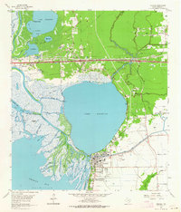 1961 Anahuac1964 Print · USGSThe Trinity River delta and the coastal prairies of Chambers County are captured here in the early sixties. Genealogists and historians can trace family sites at Wallisville Cem and Eminence, or locate the Davis Sch near Hankamer.3 unique versions available
 - 1961 Map of Oak Island, 1964 Print
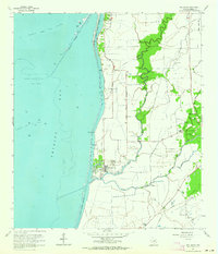 1961 Oak Island1964 Print · USGSThe Texas coast in the early sixties reveals a landscape where maritime channels and oil fields met quiet bayou communities. Genealogists and local historians can trace family sites near Oak Island, including Crook Cem, Mt Zion Ch, and the Double Bayou Sch.2 unique versions available
End of results
Showing maps 1-2 of 2
Top cities near Anahuac
- Baytown historical maps
- Texas City historical maps
- Dayton historical maps
- Mont Belvieu historical maps
- Beach City historical maps
- Old River-Winfree historical maps
See more
Frequently asked questions
- What are the different types of historical maps available for Anahuac?
- What is the oldest map of Anahuac?
- Where can I purchase historical maps of Anahuac for my home or office?
- Where can I download high-res historical maps of Anahuac?
- Are there historical topographic maps available for Anahuac?
- Is there historical aerial imagery available for Anahuac?
- Where are historical maps of Anahuac sourced from?