1900s (20th Century) Maps of Anahuac, Texas
Explore 9 historic maps of Anahuac from the 1900s (20th Century). These maps offer a rare glimpse into what life looked like during the 1900s — showing old roads, neighborhoods, homes, and landmarks that have changed or disappeared over time.
Whether you're researching your family's past, planning a metal detecting trip, or studying how Anahuac's landscape evolved across the 1900s, these high-resolution maps are a powerful tool for exploring the history of this region.
- Focus on a specific era: All maps on this page are from the 1900s, giving you a focused view of this time period.
- See what’s changed: Compare century-old streets, trails, and buildings to today's modern landscape using overlays and satellite layers.
- Research with precision: Use these maps for genealogy, historical research, land use analysis, or educational projects.
- View, download, or print: Maps are fully viewable online in high resolution, and can be downloaded or printed for your own records.
Start exploring Anahuac's history through authentic maps from the 1900s. This is your window into the past.
Anahuac, TX maps
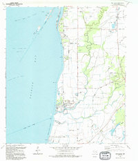
(9)- 1942 Map of Anahuac, 1958 Print
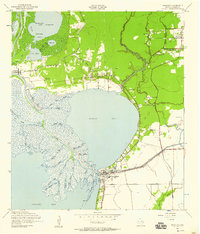 1942 Anahuac1958 Print · USGSThe mouth of the Trinity River and the shores of Turtle Bay are captured here in the early 1940s. Genealogists can trace family landmarks like Wallisville Cem and Old Fort Anahuac or locate the schools and oil wells of Wallisville and Eminence.
 - 1950 Map of Houston, 1953 Print
 1950 Houston1953 Print · USGSCoastal Texas in the early fifties reveals a landscape of massive civil engineering and industrial transit. Genealogists and researchers can trace the growth of the Houston suburbs and the maritime infrastructure of Galveston Bay, including the Gulf Freeway and the Texas City Dike.
 - 1956 Map of Houston, 1963 Print
 1956 Houston1963 Print · USGSSoutheast Texas in the mid-fifties is captured here as a powerhouse of oil and maritime trade. Genealogists and historians can trace the foundations of Houston and its ports, alongside landmarks like the Rice Institute and the Spindletop Oil Field.2 unique versions available
 - 1961 Map of Anahuac, 1964 Print
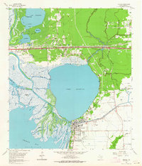 1961 Anahuac1964 Print · USGSThe Trinity River delta and the coastal prairies of Chambers County are captured here in the early sixties. Genealogists and historians can trace family sites at Wallisville Cem and Eminence, or locate the Davis Sch near Hankamer.3 unique versions available
 - 1961 Map of Oak Island, 1964 Print
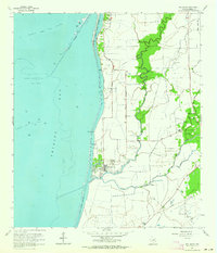 1961 Oak Island1964 Print · USGSThe Texas coast in the early sixties reveals a landscape where maritime channels and oil fields met quiet bayou communities. Genealogists and local historians can trace family sites near Oak Island, including Crook Cem, Mt Zion Ch, and the Double Bayou Sch.2 unique versions available
 - 1975 Map of Houston, 1977 Print
 1975 Houston1977 Print · USGSThe Texas Gulf Coast in the mid-seventies shows a sprawling Houston metropolis linked to the sea by the massive Houston Ship Channel. Researchers can trace the mid-century industrial landscape from the Astrodome to the Lyndon B. Johnson Space Center.2 unique versions available
 - 1983 Map of Anahuac
 1983 Anahuac1983 Print · USGSThe Upper Texas Coast and its energy-driven landscape are detailed here in the early eighties. Genealogists and historians can trace coastal settlements like Anahuac and Winnie alongside the storied Spindletop Oil Field and the Anahuac National Wildlife Refuge.2 unique versions available
 - 1993 Map of Anahuac
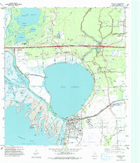 1993 Anahuac1993 Print · USGSThe Trinity River meets the Gulf coast in the early nineties, revealing a landscape defined by the Trinity River Delta and the town of Anahuac. Genealogists and local historians can trace family legacy through numerous sites like the Benjamin Barrow Cem, Wallisville Cem, and St Mary Ch.
 - 1994 Map of Oak Island
 1994 Oak Island1994 Print · USGSThe Chambers County coast and the waters of Trinity Bay are captured here during the 1990s, showcasing a landscape of oil fields and coastal bayous. Researchers can trace the development of Oak Island, protected by the Eagle Levee, and locate historical sites like Crook Cem and Mt Zion Ch.
End of results
Showing maps 1-9 of 9
Top cities near Anahuac
- Baytown historical maps
- Texas City historical maps
- Dayton historical maps
- Mont Belvieu historical maps
- Beach City historical maps
- Old River-Winfree historical maps
See more
Frequently asked questions
- What are the different types of historical maps available for Anahuac?
- What is the oldest map of Anahuac?
- Where can I purchase historical maps of Anahuac for my home or office?
- Where can I download high-res historical maps of Anahuac?
- Are there historical topographic maps available for Anahuac?
- Is there historical aerial imagery available for Anahuac?
- Where are historical maps of Anahuac sourced from?