1970s Maps of Jolly, Texas
Explore 2 historic maps of Jolly from the 1970s. These maps offer a rare glimpse into what life looked like during the 1970s — showing old roads, neighborhoods, homes, and landmarks that have changed or disappeared over time.
Whether you're researching your family's past, planning a metal detecting trip, or studying how Jolly's landscape evolved across the 1970s, these high-resolution maps are a powerful tool for exploring the history of this region.
- Focus on a specific era: All maps on this page are from the 1970s, giving you a focused view of this time period.
- See what’s changed: Compare century-old streets, trails, and buildings to today's modern landscape using overlays and satellite layers.
- Research with precision: Use these maps for genealogy, historical research, land use analysis, or educational projects.
- View, download, or print: Maps are fully viewable online in high resolution, and can be downloaded or printed for your own records.
Start exploring Jolly's history through authentic maps from the 1970s. This is your window into the past.
Jolly, TX maps
(2)- 1972 Map of Dean, 1974 Print
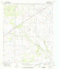 1972 Dean1974 Print · USGSClay County at the start of the seventies reveals a landscape shaped by petroleum and prairie life. Genealogists and local historians can trace the homesteads around Dean and Jolly, or locate industrial landmarks like the Petrolia Oil Field and the community Athletic Field.
 - 1972 Map of Jolly, 1975 Print
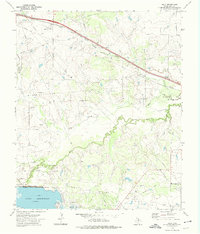 1972 Jolly1975 Print · USGSClay County in the early seventies shows a landscape where the Fort Worth and Denver railroad meets a heavy industrial presence. Researchers can trace the extensive Halsell Oil Field and the shoreline of Lake Arrowhead near the Wichita Falls Dam.
End of results
Showing maps 1-2 of 2
Top cities near Jolly
- Wichita Falls historical maps
- Burkburnett historical maps
- Henrietta historical maps
- Lakeside City historical maps
- Petrolia historical maps
- Byers historical maps
See more
Frequently asked questions
- What are the different types of historical maps available for Jolly?
- What is the oldest map of Jolly?
- Where can I purchase historical maps of Jolly for my home or office?
- Where can I download high-res historical maps of Jolly?
- Are there historical topographic maps available for Jolly?
- Is there historical aerial imagery available for Jolly?
- Where are historical maps of Jolly sourced from?