1940s Maps of King, Texas
Explore 2 historic maps of King from the 1940s. These maps offer a rare glimpse into what life looked like during the 1940s — showing old roads, neighborhoods, homes, and landmarks that have changed or disappeared over time.
Whether you're researching your family's past, planning a metal detecting trip, or studying how King's landscape evolved across the 1940s, these high-resolution maps are a powerful tool for exploring the history of this region.
- Focus on a specific era: All maps on this page are from the 1940s, giving you a focused view of this time period.
- See what’s changed: Compare century-old streets, trails, and buildings to today's modern landscape using overlays and satellite layers.
- Research with precision: Use these maps for genealogy, historical research, land use analysis, or educational projects.
- View, download, or print: Maps are fully viewable online in high resolution, and can be downloaded or printed for your own records.
Start exploring King's history through authentic maps from the 1940s. This is your window into the past.
King, TX maps
(2)- 1947 Map of Purmela, 1953 Print
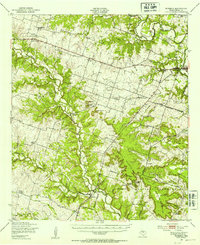 1947 Purmela1953 Print · USGSCentral Texas rural life and military expansion meet in the late 1940s as settlements like Purmela and Pidcoke border federal lands. Genealogists can trace family roots through Slater Cem, Harman Sch, and the Spring Hill Cem.
 - 1947 Map of Purmela, 1953 Print
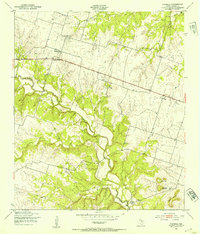 1947 Purmela1953 Print · USGSCoryell County ranching country is documented here shortly after the war, showing the network of small settlements and family landmarks. Genealogists can locate family names at Smith Cem, Purmela Sch, and the community of Arnett.
End of results
Showing maps 1-2 of 2
Top cities near King
Frequently asked questions
- What are the different types of historical maps available for King?
- What is the oldest map of King?
- Where can I purchase historical maps of King for my home or office?
- Where can I download high-res historical maps of King?
- Are there historical topographic maps available for King?
- Is there historical aerial imagery available for King?
- Where are historical maps of King sourced from?