Old Maps of Dawson County, Texas for Academic Research
Study the evolution of Dawson County with 127 high-resolution historic maps. Whether you're teaching, researching, or modeling changes in land use, these maps provide essential visual documentation of urban, environmental, and geographic change.
- Analyze long-term change: Track patterns in development, transportation, and natural features.
- Ideal for environmental or urban studies: Support academic projects with primary historical map data.
- Use in the classroom or lab: Educators and researchers rely on these maps to bring historical context to life.
These maps are a powerful tool for teaching, research, and visualizing how Dawson County has changed over the decades.
Dawson County, TX maps
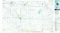
(127)- 1954 Map of Hobbs, 1963 Print
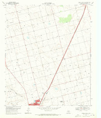
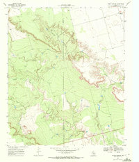
 1954 Hobbs1963 Print · USGSThe High Plains and Permian Basin transition is captured here at the height of the mid-century energy boom. Genealogists and industrial historians can trace the foundations of Humble City, locate the Potash Mine and Plant, and follow the Texas-New Mexico RR.2 unique versions available
 - 1954 Map of Big Spring, 1965 Print
 1954 Big Spring1965 Print · USGSWest Texas in the mid-1950s shows a landscape of growing oil towns and vital rail links along the Texas and Pacific RR. Researchers can trace the development of Big Spring, find smaller settlements like Knott and Lomax, or locate landmarks such as Boyds Chapel and Signal Mountain.4 unique versions available
 - 1958 Map of Big Spring
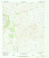
 1958 Big Spring1958 Print · USGSThe West Texas oil boom was in full swing during the late fifties, transforming the landscape around Howard and Mitchell counties. Genealogists and historians can trace the growth of Big Spring and Snyder alongside industrial landmarks like the Kelly-Snyder Oil Field and the Santa Fe rail lines.
 - 1958 Map of Hobbs
 1958 Hobbs1958 Print · USGSThe High Plains of the Texas-New Mexico border are shown here during the height of the mid-century oil boom. Genealogists and historians can trace the development of Hobbs, Lovington, and Jal, alongside ranching landmarks like James Ranch and the early Texas-New Mexico Railway.
 - 1968 Map of Lamesa North, 1971 Print
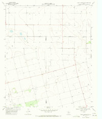
 1968 Lamesa North1971 Print · USGSThe northern reaches of Dawson County are seen here in the late sixties as the regional rail economy flourished. Researchers can trace the Atchison Topeka and Santa Fe line through Arvana or locate landmarks like Johnson Airfield.
 - 1968 Map of Hancock, 1971 Print
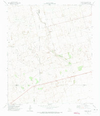
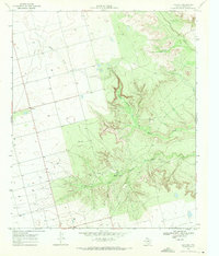 1968 Hancock1971 Print · USGSDawson County during the late sixties was a land of agricultural plains and deep canyon drainages. Researchers can trace the community around Hancock, locate a rural Cem, and follow the rugged paths of Tobacco Creek and Rock Canyon.
 - 1969 Map of Welch East, 1971 Print
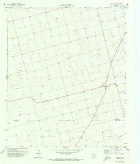
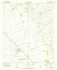
 1969 Welch East1971 Print · USGSThe Texas South Plains in the late sixties reveals a landscape shaped by the Welch Oil Field at the junction of three counties. Genealogists and researchers can locate the Pride Cem and trace the small rural communities of Pride and Milo.
 - 1969 Map of Gooch Lake, 1971 Print
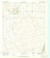 1969 Gooch Lake1971 Print · USGSThe High Plains of West Texas are captured here in the late sixties at the boundary of Dawson and Lynn counties. Trace the rail-side settlements of Grandview and Hindman along the Atchison Topeka and Santa Fe and the namesake Gooch Lake.
 - 1969 Map of O'Donnell, 1971 Print
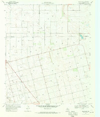
 1969 O'Donnell1971 Print · USGSThe high plains of West Texas meet the Lynn and Dawson county line in the late sixties, where the railroad drives local industry. Genealogists can locate the O'Donnell Cem and trace ranching life at Caprock Ranch or the Rodeo Ground.2 unique versions available
 - 1969 Map of Welch SW, 1971 Print
 1969 Welch SW1971 Print · USGSThe West Texas oil boom of the late sixties is on full display here along the Gaines Co Dawson Co line. Researchers can trace the intensive development of the Cedar Lake Oil Field and locate industrial landmarks like the Substation and Cedar Lake.
 - 1969 Map of Punkin Center, 1971 Print
 1969 Punkin Center1971 Print · USGSThe West Texas plains around Dawson County appear here in the late sixties, showing a landscape defined by extensive oil exploration. Genealogists and researchers can locate Fairview Cem and the small settlements of Punkin Center and Mungerville along the path of Sulphur Springs Draw.
 - 1969 Map of Welch West, 1971 Print
 1969 Welch West1971 Print · USGSDawson County and its neighbors are captured here in the late sixties at the height of the local petroleum boom. You can trace the sprawling infrastructure of the Welch Oil Field, the streets of Welch, and the natural path of Sulphur Springs Draw.
 - 1969 Map of Indian Canyon, 1972 Print
 1969 Indian Canyon1972 Print · USGSThe rugged canyons of the West Texas caprock are captured here in the late sixties as the oil industry expanded across the county line. Researchers can trace the winding Outlaw Road and locate remote sites like Mesquite or the Oil Wells tucked into Indian Canyon.
 - 1970 Map of Indian Canyon NW, 1971 Print
 1970 Indian Canyon NW1971 Print · USGSTexas High Plains life in the early seventies centered on remote county line junctions and deep water wells. Genealogists and local historians can trace the rural landscape through Plain View Cem, the community at Plains, and Berry Flat Ch.
 - 1970 Map of Patricia SW, 1973 Print
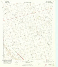
 1970 Patricia SW1973 Print · USGSThe West Texas plains at the start of the 1970s are defined here by petroleum exploration and the intersection of four county lines. Researchers can trace land use through Oil Wells, McKenzie Draw, and the isolated Mill in the Flat Pond.
 - 1970 Map of Patricia, 1973 Print
 1970 Patricia1973 Print · USGSDawson and Martin counties appear here in the early seventies during a period of steady petroleum development. Researchers can locate the Patricia settlement and trace the extent of the Breedlove Oil Field and various Gravel Pits.
 - 1970 Map of Lamesa South, 1973 Print
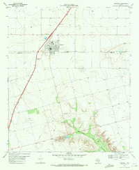
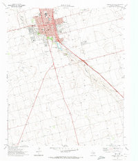 1970 Lamesa South1973 Print · USGSLamesa and the surrounding South Plains are captured in the early 1970s as the town expanded around its rail and oil interests. Genealogists can trace family landmarks like Memorial Park (Cem) or local schools including V Z Rogers Sch and South Sch.
 - 1970 Map of Ackerly, 1973 Print
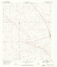
 1970 Ackerly1973 Print · USGSAckerly and the surrounding High Plains are captured here in the early seventies, at the intersection of four Texas counties. Researchers can trace the layout of the Sands Sch, locate the Fairhaven Cem, and see the extent of the local Oil Field.
 - 1970 Map of Key, 1973 Print
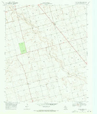
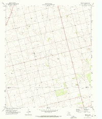
 1970 Key1973 Print · USGSTexas petroleum production was in full swing during the early seventies, centered around the rural communities of Dawson County. Researchers can trace the development of the Spraberry Oil Field and find family sites like Midway Cem and Key.
 - 1970 Map of Tenmile, 1973 Print
 1970 Tenmile1973 Print · USGSDawson and Martin Counties are captured during a period of significant petroleum development in the early seventies. Genealogists and industrial historians can trace the foundations of Klondike and its High Sch alongside the sprawling Tex Hamon Oil Field.
 - 1970 Map of Sand, 1973 Print
 1970 Sand1973 Print · USGSThe West Texas plains at the start of the 1970s reveal a landscape shaped by the energy industry and the quiet crossing of McKenzie Draw. Researchers can trace the industrial footprint of the era through numerous Oil Wells, a Pumping Sta, and the community of Sand.
 - 1970 Map of Sand Creek, 1974 Print
 1970 Sand Creek1974 Print · USGSBorden County in the early seventies shows the footprint of the petroleum industry across the high plains breaks. Genealogists and researchers can locate remote sites like Wasson and Southard 2 while tracing the Colorado River and the winding Outlaw Road.
 - 1970 Map of Patricia NE, 1974 Print
 1970 Patricia NE1974 Print · USGSDawson County at the start of the 1970s reveals a landscape transformed by petroleum extraction and ranching infrastructure. Researchers can trace the layout of the Gin Oil Field and locate rural landmarks like Union, Friendship, and the Landing Strip.
 - 1970 Map of Sparenberg, 1974 Print
 1970 Sparenberg1974 Print · USGSDawson County in the early seventies reflects the intersection of Texas ranching and the petroleum industry. Genealogists and local historians can trace the Ackerly Oil Field and small communities like Sparenberg and Mosley.
 - 1985 Map of Seminole, 1986 Print
 1985 Seminole1986 Print · USGSGaines County and its neighbors are captured in the mid-eighties during a period of sustained energy production and agricultural persistence. Researchers can trace the sprawling oil fields and rail stops along the Atchison Topeka and Santa Fe near Denver City and Mungerville.
Showing maps 1-25 of 127
Top cities of Dawson County
Frequently asked questions
- What are the different types of historical maps available for Dawson County?
- What is the oldest map of Dawson County?
- Where can I purchase historical maps of Dawson County for my home or office?
- Where can I download high-res historical maps of Dawson County?
- Are there historical topographic maps available for Dawson County?
- Is there historical aerial imagery available for Dawson County?
- Where are historical maps of Dawson County sourced from?