1960s Maps of Dawson County, Texas
Explore 9 historic maps of Dawson County from the 1960s. These maps offer a rare glimpse into what life looked like during the 1960s — showing old roads, neighborhoods, homes, and landmarks that have changed or disappeared over time.
Whether you're researching your family's past, planning a metal detecting trip, or studying how Dawson County's landscape evolved across the 1960s, these high-resolution maps are a powerful tool for exploring the history of this region.
- Focus on a specific era: All maps on this page are from the 1960s, giving you a focused view of this time period.
- See what’s changed: Compare century-old streets, trails, and buildings to today's modern landscape using overlays and satellite layers.
- Research with precision: Use these maps for genealogy, historical research, land use analysis, or educational projects.
- View, download, or print: Maps are fully viewable online in high resolution, and can be downloaded or printed for your own records.
Start exploring Dawson County's history through authentic maps from the 1960s. This is your window into the past.
Dawson County, TX maps
(9)- 1968 Map of Lamesa North, 1971 Print
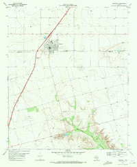
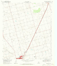 1968 Lamesa North1971 Print · USGSThe northern reaches of Dawson County are seen here in the late sixties as the regional rail economy flourished. Researchers can trace the Atchison Topeka and Santa Fe line through Arvana or locate landmarks like Johnson Airfield.
 - 1968 Map of Hancock, 1971 Print
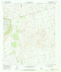
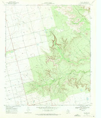 1968 Hancock1971 Print · USGSDawson County during the late sixties was a land of agricultural plains and deep canyon drainages. Researchers can trace the community around Hancock, locate a rural Cem, and follow the rugged paths of Tobacco Creek and Rock Canyon.
 - 1969 Map of Welch East, 1971 Print
 1969 Welch East1971 Print · USGSThe Texas South Plains in the late sixties reveals a landscape shaped by the Welch Oil Field at the junction of three counties. Genealogists and researchers can locate the Pride Cem and trace the small rural communities of Pride and Milo.
 - 1969 Map of Gooch Lake, 1971 Print
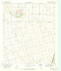 1969 Gooch Lake1971 Print · USGSThe High Plains of West Texas are captured here in the late sixties at the boundary of Dawson and Lynn counties. Trace the rail-side settlements of Grandview and Hindman along the Atchison Topeka and Santa Fe and the namesake Gooch Lake.
 - 1969 Map of O'Donnell, 1971 Print
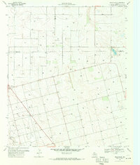
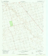
 1969 O'Donnell1971 Print · USGSThe high plains of West Texas meet the Lynn and Dawson county line in the late sixties, where the railroad drives local industry. Genealogists can locate the O'Donnell Cem and trace ranching life at Caprock Ranch or the Rodeo Ground.2 unique versions available
 - 1969 Map of Welch SW, 1971 Print
 1969 Welch SW1971 Print · USGSThe West Texas oil boom of the late sixties is on full display here along the Gaines Co Dawson Co line. Researchers can trace the intensive development of the Cedar Lake Oil Field and locate industrial landmarks like the Substation and Cedar Lake.
 - 1969 Map of Punkin Center, 1971 Print
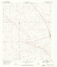
 1969 Punkin Center1971 Print · USGSThe West Texas plains around Dawson County appear here in the late sixties, showing a landscape defined by extensive oil exploration. Genealogists and researchers can locate Fairview Cem and the small settlements of Punkin Center and Mungerville along the path of Sulphur Springs Draw.
 - 1969 Map of Welch West, 1971 Print
 1969 Welch West1971 Print · USGSDawson County and its neighbors are captured here in the late sixties at the height of the local petroleum boom. You can trace the sprawling infrastructure of the Welch Oil Field, the streets of Welch, and the natural path of Sulphur Springs Draw.
 - 1969 Map of Indian Canyon, 1972 Print
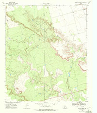 1969 Indian Canyon1972 Print · USGSThe rugged canyons of the West Texas caprock are captured here in the late sixties as the oil industry expanded across the county line. Researchers can trace the winding Outlaw Road and locate remote sites like Mesquite or the Oil Wells tucked into Indian Canyon.
End of results
Showing maps 1-9 of 9
Top cities of Dawson County
Frequently asked questions
- What are the different types of historical maps available for Dawson County?
- What is the oldest map of Dawson County?
- Where can I purchase historical maps of Dawson County for my home or office?
- Where can I download high-res historical maps of Dawson County?
- Are there historical topographic maps available for Dawson County?
- Is there historical aerial imagery available for Dawson County?
- Where are historical maps of Dawson County sourced from?