1990s Maps of Donley County, Texas
Explore 2 historic maps of Donley County from the 1990s. These maps offer a rare glimpse into what life looked like during the 1990s — showing old roads, neighborhoods, homes, and landmarks that have changed or disappeared over time.
Whether you're researching your family's past, planning a metal detecting trip, or studying how Donley County's landscape evolved across the 1990s, these high-resolution maps are a powerful tool for exploring the history of this region.
- Focus on a specific era: All maps on this page are from the 1990s, giving you a focused view of this time period.
- See what’s changed: Compare century-old streets, trails, and buildings to today's modern landscape using overlays and satellite layers.
- Research with precision: Use these maps for genealogy, historical research, land use analysis, or educational projects.
- View, download, or print: Maps are fully viewable online in high resolution, and can be downloaded or printed for your own records.
Start exploring Donley County's history through authentic maps from the 1990s. This is your window into the past.
Donley County, TX maps
(2)- 1998 Map of Rockledge, 2001 Print
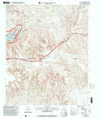 1998 Rockledge2001 Print · USGSThe Texas Panhandle at the close of the twentieth century reveals a landscape defined by the GAS FIELD and the McClellan Creek National Grassland. Genealogists and local historians can trace family-named sites like Johnson Ranch and the small communities of Rockledge and Reed.
 - 1998 Map of Jericho, 2001 Print
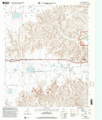 1998 Jericho2001 Print · USGSThe Texas Panhandle comes into focus during the late nineties, showing the rural landscape around the settlement of Jericho. Researchers can locate historic burial grounds like Jericho Cem and trace the McClellan Creek Trail through the national grassland.
End of results
Showing maps 1-2 of 2
Top cities of Donley County
Frequently asked questions
- What are the different types of historical maps available for Donley County?
- What is the oldest map of Donley County?
- Where can I purchase historical maps of Donley County for my home or office?
- Where can I download high-res historical maps of Donley County?
- Are there historical topographic maps available for Donley County?
- Is there historical aerial imagery available for Donley County?
- Where are historical maps of Donley County sourced from?