1960s Maps of Donley County, Texas
Explore 18 historic maps of Donley County from the 1960s. These maps offer a rare glimpse into what life looked like during the 1960s — showing old roads, neighborhoods, homes, and landmarks that have changed or disappeared over time.
Whether you're researching your family's past, planning a metal detecting trip, or studying how Donley County's landscape evolved across the 1960s, these high-resolution maps are a powerful tool for exploring the history of this region.
- Focus on a specific era: All maps on this page are from the 1960s, giving you a focused view of this time period.
- See what’s changed: Compare century-old streets, trails, and buildings to today's modern landscape using overlays and satellite layers.
- Research with precision: Use these maps for genealogy, historical research, land use analysis, or educational projects.
- View, download, or print: Maps are fully viewable online in high resolution, and can be downloaded or printed for your own records.
Start exploring Donley County's history through authentic maps from the 1960s. This is your window into the past.
Donley County, TX maps
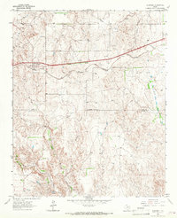
(18)- 1960 Map of Groom, 1961 Print
 1960 Groom1961 Print · USGSThe Texas Panhandle plains meet the breaks of the Red River in the 1960s, where ranching culture and rail lines converge. Genealogists and historians can locate family landmarks like the Goodnight Cem and trace cattle operations at Thornberry Ranch or SJ Ranch.
 - 1960 Map of Indian Peak, 1963 Print
 1960 Indian Peak1963 Print · USGSBriscoe County ranching and the deep cuts of the Panhandle canyons are recorded here in the early sixties. Researchers can find old cattle camps and family holdings including Woodburn Ranch, Indian Peak, and the Stinkhole Divide.
 - 1960 Map of Brice, 1963 Print
 1960 Brice1963 Print · USGSHall County ranching and the rugged breaks of the Red River are documented here in the early sixties. Genealogists and historians can trace family landholdings like Shoe Bar Ranch and locate the Hickman Sch or the remote Oxbow Ranch.
 - 1961 Map of Memphis, 1963 Print
 1961 Memphis1963 Print · USGSThe Texas Panhandle is captured here in the early sixties as a network of rail-side settlements and wide river basins. Genealogists and local historians can trace the foundations of Memphis or locate rural sites like Plaska, Hulver Cemetery, and the Travis School.
 - 1962 Map of Lelia Lake, 1963 Print
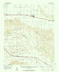
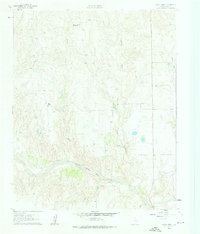
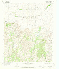
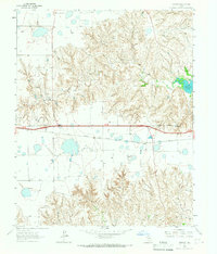
 1962 Lelia Lake1963 Print · USGSDonley County ranching and rail life are on full display in the early sixties as the Texas Panhandle transitioned into the modern era. Trace the path of the FT Worth and Denver railroad through Lelia Lake or locate early water features like Johnson Lake.2 unique versions available
 - 1962 Map of Roach Ranch, 1963 Print
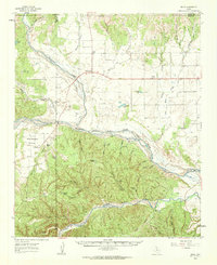
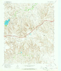
 1962 Roach Ranch1963 Print · USGSDonley County ranch lands and river breaks are captured here in the early sixties, showing the transition between open range and developing leisure. Trace the waters of the Salt Fork Red River past Roach Ranch and the Clarendon Country Club.3 unique versions available
 - 1962 Map of Griffin Ranch, 1963 Print
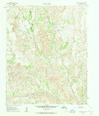 1962 Griffin Ranch1963 Print · USGSDonley County ranching operations are captured in the early 1960s, showing the distribution of family-named spreads across the Texas Panhandle. Trace the network of seasonal waterways from Big Sandy Creek to the Salt Fork Red River, and locate remote landmarks like Griffin North Ranch and Mc Murtry.2 unique versions available
 - 1963 Map of Hedley, 1965 Print
 1963 Hedley1965 Print · USGSHedley and the surrounding Panhandle plains are documented in the early sixties, showing the vital link provided by the Fort Worth and Denver railroad. Trace family land near Indian Creek Ranch or early industry at the Gravel Pits and Quarries.2 unique versions available
 - 1963 Map of Clarendon, 1966 Print
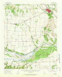
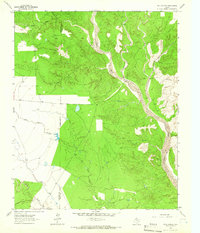
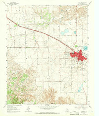 1963 Clarendon1966 Print · USGSDonley County centers on the rail-and-road hub of Clarendon in the early sixties as the regional economy transitioned between ranching and civic expansion. Researchers can find family roots at St Marys Cem and Citizens Cem or trace the path of the Fort Worth and Denver line.2 unique versions available
 - 1963 Map of Buffalo Arroyo, 1966 Print
 1963 Buffalo Arroyo1966 Print · USGSDonley County and the Armstrong line appear in the early sixties as a rugged landscape of Panhandle breaks and creek beds. Trace the winding course of Mulberry Creek or locate local landmarks like the Fort Worth and Denver railroad and Buffalo Arroyo.
 - 1963 Map of Clarendon SE, 1966 Print
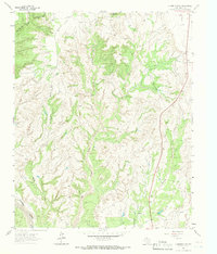
 1963 Clarendon SE1966 Print · USGSDonley County ranch lands and the rugged breaks of the eastern Panhandle are captured here in the early sixties. Genealogists and local historians can trace the foundations of the Chamberlain Community Center and remote outposts like Bitter Creek Ranch (West Hdqrs).
 - 1963 Map of Tate Arroyo, 1966 Print
 1963 Tate Arroyo1966 Print · USGSDonley and Armstrong counties in the early 1960s reveal a landscape of expansive cattle ranges and intricate canyon drainages. Researchers can trace historic fence lines and cattle-country landmarks like Payne Flat, Tate Arroyo, and the broad bed of Mulberry Creek.
 - 1963 Map of Giles, 1966 Print
 1963 Giles1966 Print · USGSDonley County's ranching and rail landscape is meticulously captured here in the early sixties. Genealogists and historians can trace the Fort Worth and Denver railroad through Giles, locate old Gravel Pits, and map family property via historical fence lines.2 unique versions available
 - 1963 Map of Clarendon SW, 1966 Print
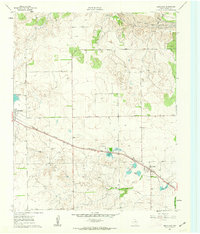
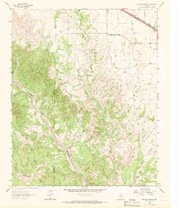
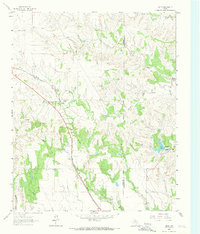
 1963 Clarendon SW1966 Print · USGSThe Texas Panhandle breaks south of Clarendon are captured here in the early sixties, showing a landscape shaped by ranching and erosion. Trace the deep cuts of Troublesome Canyon and Mulberry Creek or locate landmarks like Gunboat Mountain.
 - 1963 Map of Alanreed, 1967 Print
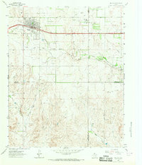
 1963 Alanreed1967 Print · USGSIn the early sixties, the Texas Panhandle community of Alanreed served as a key transit point for the CHICAGO ROCK ISLAND AND PACIFIC railroad. Local researchers can trace family landmarks like Alanreed Cem and the winding course of Whitefish Creek.2 unique versions available
 - 1963 Map of McLean, 1967 Print
 1963 McLean1967 Print · USGSMcLean and the surrounding High Plains ranch lands are captured here in the early sixties as the town grew along the Chicago Rock Island and Pacific rail line. Researchers can locate the Hillcrest Cem, trace the local Rodeo Ground, and find long-standing landmarks like the Drive-in Theater.2 unique versions available
 - 1964 Map of Jericho, 1967 Print
 1964 Jericho1967 Print · USGSThe Texas Panhandle in the early sixties reveals a landscape of cattle-guard gates and rural industry. Genealogists and historians can trace family locations near Jericho Cem, the Chicago Rock Island and Pacific line, and Boydston Cemetery.
 - 1964 Map of Rockledge, 1967 Print
 1964 Rockledge1967 Print · USGSThe Texas Panhandle in the early sixties is captured here as a landscape of ranching, energy extraction, and critical rail transport. Genealogists and historians can trace the Chicago Rock Island and Pacific rail line through Rockledge and locate family landmarks like Johnson Ranch.
End of results
Showing maps 1-18 of 18
Top cities of Donley County
Frequently asked questions
- What are the different types of historical maps available for Donley County?
- What is the oldest map of Donley County?
- Where can I purchase historical maps of Donley County for my home or office?
- Where can I download high-res historical maps of Donley County?
- Are there historical topographic maps available for Donley County?
- Is there historical aerial imagery available for Donley County?
- Where are historical maps of Donley County sourced from?