1940s Maps of Arts Festival Plaza, El Paso
Explore 5 historic maps of Arts Festival Plaza from the 1940s. These maps offer a rare glimpse into what life looked like during the 1940s — showing old roads, neighborhoods, homes, and landmarks that have changed or disappeared over time.
Whether you're researching your family's past, planning a metal detecting trip, or studying how Arts Festival Plaza's landscape evolved across the 1940s, these high-resolution maps are a powerful tool for exploring the history of this region.
- Focus on a specific era: All maps on this page are from the 1940s, giving you a focused view of this time period.
- See what’s changed: Compare century-old streets, trails, and buildings to today's modern landscape using overlays and satellite layers.
- Research with precision: Use these maps for genealogy, historical research, land use analysis, or educational projects.
- View, download, or print: Maps are fully viewable online in high resolution, and can be downloaded or printed for your own records.
Start exploring Arts Festival Plaza's history through authentic maps from the 1940s. This is your window into the past.
Arts Festival Plaza, El Paso maps
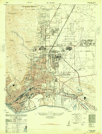
(5)- 1941 Map of El Paso
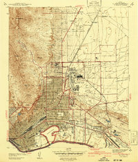 1941 El Paso1941 Print · USGSEl Paso and the borderlands are seen here just before the massive expansion of the mid-century, defined by the mountain peaks and the shifting river. Researchers can trace the unusual boundary at Cordova Island, locate early schools like Radford Sch, or find family names at Tobin Ranch.
 - 1942 Map of Fort Bliss
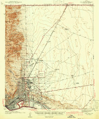 1942 Fort Bliss1942 Print · USGSEl Paso and its military neighbors are captured here in the early 1940s as the desert landscape rapidly modernized. Researchers can trace family ranching sites like Tobin Ranch alongside the expansion of Fort Bliss and the Biggs Field.
 - 1943 Map of El Paso
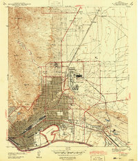 1943 El Paso1943 Print · USGSEl Paso at the start of the 1940s reveals a city shaped by international borders and heavy industry. Genealogists can trace family roots through local schools like Radford Sch and Cooley Sch or locate ancestors at Restlawn Cemetery.
 - 1945 Map of Fort Bliss
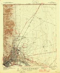 1945 Fort Bliss1945 Print · USGSEl Paso and its military environs are captured here during the mid-1940s, showing the intersection of rapid defense growth and desert ranching. Genealogists and historians can trace family sites like Tobin Ranch, locate the CCC Camp, and study the early layout of Biggs Field.
 - 1948 Map of El Paso
 1948 El Paso1948 Print · USGSEl Paso and its surrounding military lands are captured here just after the war, showing the city's expansion toward the Franklin Mountains. Genealogists and researchers can trace family homes near Kern Place or locate early landmarks like Austin High School and Ascarate Lake.
End of results
Showing maps 1-5 of 5
Frequently asked questions
- What are the different types of historical maps available for Arts Festival Plaza?
- What is the oldest map of Arts Festival Plaza?
- Where can I purchase historical maps of Arts Festival Plaza for my home or office?
- Where can I download high-res historical maps of Arts Festival Plaza?
- Are there historical topographic maps available for Arts Festival Plaza?
- Is there historical aerial imagery available for Arts Festival Plaza?
- Where are historical maps of Arts Festival Plaza sourced from?