1990s Maps of Britton Davis, El Paso
Explore 2 historic maps of Britton Davis from the 1990s. These maps offer a rare glimpse into what life looked like during the 1990s — showing old roads, neighborhoods, homes, and landmarks that have changed or disappeared over time.
Whether you're researching your family's past, planning a metal detecting trip, or studying how Britton Davis's landscape evolved across the 1990s, these high-resolution maps are a powerful tool for exploring the history of this region.
- Focus on a specific era: All maps on this page are from the 1990s, giving you a focused view of this time period.
- See what’s changed: Compare century-old streets, trails, and buildings to today's modern landscape using overlays and satellite layers.
- Research with precision: Use these maps for genealogy, historical research, land use analysis, or educational projects.
- View, download, or print: Maps are fully viewable online in high resolution, and can be downloaded or printed for your own records.
Start exploring Britton Davis's history through authentic maps from the 1990s. This is your window into the past.
Britton Davis, El Paso maps
(2)- 1994 Map of El Paso
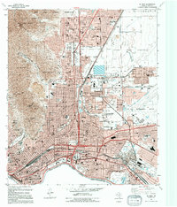 1994 El Paso1994 Print · USGSEl Paso's urban and military landscape is captured in the early 1990s as it reaches toward the Franklin Mountains. Trace the international border at the Chamizal National Memorial or locate family history at Concordia Cemetery and Britton Davis.
 - 1997 Map of El Paso, 1999 Print
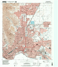 1997 El Paso1999 Print · USGSEl Paso and the borderlands are captured here in the late nineties, showcasing the city's complex relationship with the river and the mountains. Researchers can trace the boundaries of Fort Bliss, locate graves at Concordia Cemetery, or follow the Southern Pacific rail lines.
End of results
Showing maps 1-2 of 2
Top cities near Britton Davis
- El Paso historical maps
- Socorro historical maps
- Sunland Park historical maps
- Chaparral historical maps
- Horizon City historical maps
- Anthony historical maps
See more
Frequently asked questions
- What are the different types of historical maps available for Britton Davis?
- What is the oldest map of Britton Davis?
- Where can I purchase historical maps of Britton Davis for my home or office?
- Where can I download high-res historical maps of Britton Davis?
- Are there historical topographic maps available for Britton Davis?
- Is there historical aerial imagery available for Britton Davis?
- Where are historical maps of Britton Davis sourced from?