1910s Maps of Coronado Hills, El Paso
Explore 2 historic maps of Coronado Hills from the 1910s. These maps offer a rare glimpse into what life looked like during the 1910s — showing old roads, neighborhoods, homes, and landmarks that have changed or disappeared over time.
Whether you're researching your family's past, planning a metal detecting trip, or studying how Coronado Hills's landscape evolved across the 1910s, these high-resolution maps are a powerful tool for exploring the history of this region.
- Focus on a specific era: All maps on this page are from the 1910s, giving you a focused view of this time period.
- See what’s changed: Compare century-old streets, trails, and buildings to today's modern landscape using overlays and satellite layers.
- Research with precision: Use these maps for genealogy, historical research, land use analysis, or educational projects.
- View, download, or print: Maps are fully viewable online in high resolution, and can be downloaded or printed for your own records.
Start exploring Coronado Hills's history through authentic maps from the 1910s. This is your window into the past.
Coronado Hills, El Paso maps
(2)- 1917 Map of Canutillo, 1957 Print
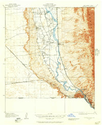 1917 Canutillo1957 Print · USGSThe Rio Grande valley and the international border come to life in this survey from the early twentieth century. Genealogists and researchers can trace the rail-and-river economy through old stations like Strauss, local landmarks like La Vista School, and the industrial Smelter district.
 - 1919 Map of Canutillo
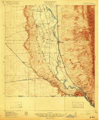 1919 Canutillo1919 Print · USGSThe Rio Grande valley at the Texas and New Mexico border comes to life in this survey from just after the Great War. Genealogists and historians can trace family-named locations and early institutions like La Vista School, the Smelter, and West El Paso PO.3 unique versions available
End of results
Showing maps 1-2 of 2
Top cities near Coronado Hills
- El Paso historical maps
- Socorro historical maps
- Sunland Park historical maps
- Chaparral historical maps
- Anthony historical maps
- Anthony, NM historical maps
See more
Frequently asked questions
- What are the different types of historical maps available for Coronado Hills?
- What is the oldest map of Coronado Hills?
- Where can I purchase historical maps of Coronado Hills for my home or office?
- Where can I download high-res historical maps of Coronado Hills?
- Are there historical topographic maps available for Coronado Hills?
- Is there historical aerial imagery available for Coronado Hills?
- Where are historical maps of Coronado Hills sourced from?