1910s Maps of Prado Verde Addition Number 1 Colonia, Texas
Explore 2 historic maps of Prado Verde Addition Number 1 Colonia from the 1910s. These maps offer a rare glimpse into what life looked like during the 1910s — showing old roads, neighborhoods, homes, and landmarks that have changed or disappeared over time.
Whether you're researching your family's past, planning a metal detecting trip, or studying how Prado Verde Addition Number 1 Colonia's landscape evolved across the 1910s, these high-resolution maps are a powerful tool for exploring the history of this region.
- Focus on a specific era: All maps on this page are from the 1910s, giving you a focused view of this time period.
- See what’s changed: Compare century-old streets, trails, and buildings to today's modern landscape using overlays and satellite layers.
- Research with precision: Use these maps for genealogy, historical research, land use analysis, or educational projects.
- View, download, or print: Maps are fully viewable online in high resolution, and can be downloaded or printed for your own records.
Start exploring Prado Verde Addition Number 1 Colonia's history through authentic maps from the 1910s. This is your window into the past.
Prado Verde Addition Number 1 Colonia, TX maps
(2)- 1917 Map of Canutillo, 1957 Print
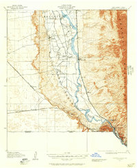 1917 Canutillo1957 Print · USGSThe Rio Grande valley and the international border come to life in this survey from the early twentieth century. Genealogists and researchers can trace the rail-and-river economy through old stations like Strauss, local landmarks like La Vista School, and the industrial Smelter district.
 - 1919 Map of Canutillo
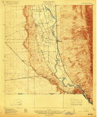 1919 Canutillo1919 Print · USGSThe Rio Grande valley at the Texas and New Mexico border comes to life in this survey from just after the Great War. Genealogists and historians can trace family-named locations and early institutions like La Vista School, the Smelter, and West El Paso PO.3 unique versions available
End of results
Showing maps 1-2 of 2
Top cities near Prado Verde Addition Number 1 Colonia
- El Paso historical maps
- Sunland Park historical maps
- Chaparral historical maps
- Anthony historical maps
- Anthony, NM historical maps
- Canutillo historical maps
See more
Frequently asked questions
- What are the different types of historical maps available for Prado Verde Addition Number 1 Colonia?
- What is the oldest map of Prado Verde Addition Number 1 Colonia?
- Where can I purchase historical maps of Prado Verde Addition Number 1 Colonia for my home or office?
- Where can I download high-res historical maps of Prado Verde Addition Number 1 Colonia?
- Are there historical topographic maps available for Prado Verde Addition Number 1 Colonia?
- Is there historical aerial imagery available for Prado Verde Addition Number 1 Colonia?
- Where are historical maps of Prado Verde Addition Number 1 Colonia sourced from?