1940s Maps of Tornillo, Texas
Explore 2 historic maps of Tornillo from the 1940s. These maps offer a rare glimpse into what life looked like during the 1940s — showing old roads, neighborhoods, homes, and landmarks that have changed or disappeared over time.
Whether you're researching your family's past, planning a metal detecting trip, or studying how Tornillo's landscape evolved across the 1940s, these high-resolution maps are a powerful tool for exploring the history of this region.
- Focus on a specific era: All maps on this page are from the 1940s, giving you a focused view of this time period.
- See what’s changed: Compare century-old streets, trails, and buildings to today's modern landscape using overlays and satellite layers.
- Research with precision: Use these maps for genealogy, historical research, land use analysis, or educational projects.
- View, download, or print: Maps are fully viewable online in high resolution, and can be downloaded or printed for your own records.
Start exploring Tornillo's history through authentic maps from the 1940s. This is your window into the past.
Tornillo, TX maps
(2)- 1941 Map of Tornillo
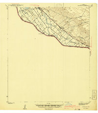 1941 Tornillo1941 Print · USGSEl Paso County's borderlands and irrigation networks are shown here at the start of the 1940s. Genealogists and historians can trace the foundations of Fabens, locate Adobe Houses, and follow the Southern Pacific railroad past Tornillo.
 - 1945 Map of Tornillo
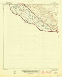 1945 Tornillo1945 Print · USGSEl Paso County's river valley and borderlands are captured here during the mid-1940s, showing the vital irrigation and rail networks of the era. Researchers can trace the Southern Pacific line past Tornillo and locate specific sites like Adobe Houses and Alamo Alto.2 unique versions available
End of results
Showing maps 1-2 of 2
Top cities near Tornillo
- El Paso historical maps
- Socorro historical maps
- Horizon City historical maps
- San Elizario historical maps
- Fabens historical maps
- Clint historical maps
Frequently asked questions
- What are the different types of historical maps available for Tornillo?
- What is the oldest map of Tornillo?
- Where can I purchase historical maps of Tornillo for my home or office?
- Where can I download high-res historical maps of Tornillo?
- Are there historical topographic maps available for Tornillo?
- Is there historical aerial imagery available for Tornillo?
- Where are historical maps of Tornillo sourced from?