1900s (20th Century) Maps of Dublin, Texas
Explore 6 historic maps of Dublin from the 1900s (20th Century). These maps offer a rare glimpse into what life looked like during the 1900s — showing old roads, neighborhoods, homes, and landmarks that have changed or disappeared over time.
Whether you're researching your family's past, planning a metal detecting trip, or studying how Dublin's landscape evolved across the 1900s, these high-resolution maps are a powerful tool for exploring the history of this region.
- Focus on a specific era: All maps on this page are from the 1900s, giving you a focused view of this time period.
- See what’s changed: Compare century-old streets, trails, and buildings to today's modern landscape using overlays and satellite layers.
- Research with precision: Use these maps for genealogy, historical research, land use analysis, or educational projects.
- View, download, or print: Maps are fully viewable online in high resolution, and can be downloaded or printed for your own records.
Start exploring Dublin's history through authentic maps from the 1900s. This is your window into the past.
Dublin, TX maps
(6)- 1920 Map of Stephenville
 1920 Stephenville1920 Print · USGSErath County thrived at the intersection of three major railroads during the early twentieth century. Genealogists and historians can trace the foundations of Stephenville and Dublin, alongside rural landmarks like Morgan Mill and Tanner School.
 - 1954 Map of Abilene, 1966 Print
 1954 Abilene1966 Print · USGSThe Texas Big Country comes into focus in the mid-1950s as petroleum and new water projects reshape the landscape. Local historians can trace the Butterfield Trail, find the Fort Phantom Hill Ruins, and locate numerous small communities along the Texas & Pacific line.2 unique versions available
 - 1958 Map of Abilene
 1958 Abilene1958 Print · USGSMid-century West Texas comes alive in this survey of the Abilene and Stephenville region during a period of steady oil expansion and military growth. Genealogists and local historians can trace the paths of the Texas & Pacific RR through historic towns, locate the Fort Griffin Ruins, and find smaller settlements like Desdemona and Lueders.
 - 1965 Map of Dublin, 1967 Print
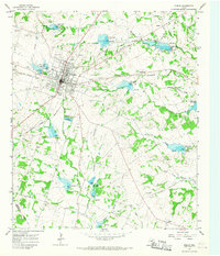 1965 Dublin1967 Print · USGSDublin is shown as a thriving rail hub in the mid-sixties at the junction of two major western railroads. Researchers can trace the local landscape through landmarks like Memorial Stadium, the Live Oak Cem, and the community of Alexander.
 - 1965 Map of Comyn, 1967 Print
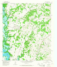 1965 Comyn1967 Print · USGSThe Comanche and Erath County line in the mid-sixties reveals a landscape defined by new water projects and established rail corridors. Researchers can trace the heritage of Comyn and Roch alongside rural landmarks like Pleasant Home Ch and several early cemeteries.2 unique versions available
 - 1985 Map of Stephenville
 1985 Stephenville1985 Print · USGSNorth Central Texas in the mid-eighties shows a landscape defined by ranching, rail history, and early oil towns. Genealogists and historians can trace the paths of the Texas Central railroad and locate rural communities like Desdemona, Lingleville, and Punkin Center.2 unique versions available
End of results
Showing maps 1-6 of 6
Top cities near Dublin
Frequently asked questions
- What are the different types of historical maps available for Dublin?
- What is the oldest map of Dublin?
- Where can I purchase historical maps of Dublin for my home or office?
- Where can I download high-res historical maps of Dublin?
- Are there historical topographic maps available for Dublin?
- Is there historical aerial imagery available for Dublin?
- Where are historical maps of Dublin sourced from?