1960s Maps of Fair Oaks Ranch, Texas
Explore 4 historic maps of Fair Oaks Ranch from the 1960s. These maps offer a rare glimpse into what life looked like during the 1960s — showing old roads, neighborhoods, homes, and landmarks that have changed or disappeared over time.
Whether you're researching your family's past, planning a metal detecting trip, or studying how Fair Oaks Ranch's landscape evolved across the 1960s, these high-resolution maps are a powerful tool for exploring the history of this region.
- Focus on a specific era: All maps on this page are from the 1960s, giving you a focused view of this time period.
- See what’s changed: Compare century-old streets, trails, and buildings to today's modern landscape using overlays and satellite layers.
- Research with precision: Use these maps for genealogy, historical research, land use analysis, or educational projects.
- View, download, or print: Maps are fully viewable online in high resolution, and can be downloaded or printed for your own records.
Start exploring Fair Oaks Ranch's history through authentic maps from the 1960s. This is your window into the past.
Fair Oaks Ranch, TX maps
(4)- 1964 Map of Boerne, 1967 Print
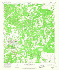 1964 Boerne1967 Print · USGSMid-century Boerne serves as the anchor for this 1960s Hill Country survey as the town begins to expand around its historic rail line. Researchers can locate family landmarks like Phillips Cem, the Herff Park Fairground, and the subterranean Cascade Cavern.4 unique versions available
 - 1964 Map of Bergheim, 1967 Print
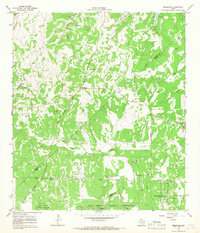 1964 Bergheim1967 Print · USGSThe Texas Hill Country at the intersection of Kendall and Comal counties is captured here in the mid-1960s as rural crossroads began to evolve. Researchers can locate several family burial sites including Willke Cem and Honey Creek Cem, or trace the winding course of Cibolo Creek.2 unique versions available
 - 1965 Map of Camp Bullis, 1966 Print
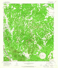 1965 Camp Bullis1966 Print · USGSBexar County was a hub of military training in the mid-1960s, defined by the expansive Leon Springs Military Reservation. Researchers can trace the Government Railroad and locate family landmarks like the Goforth Cem or Schasse Hill.2 unique versions available
 - 1967 Map of Van Raub, 1969 Print
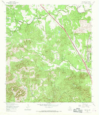 1967 Van Raub1969 Print · USGSBexar County's Hill Country transition comes into focus in the late 1960s as suburban growth began to meet historic ranchlands. Researchers can trace the Southern Pacific rail line, old school sites at Leon Springs, and family burial grounds like Robles Cem.3 unique versions available
End of results
Showing maps 1-4 of 4
Top cities near Fair Oaks Ranch
- San Antonio historical maps
- Boerne historical maps
- Helotes historical maps
- Bulverde historical maps
- Castle Hills historical maps
- Hollywood Park historical maps
See more
Frequently asked questions
- What are the different types of historical maps available for Fair Oaks Ranch?
- What is the oldest map of Fair Oaks Ranch?
- Where can I purchase historical maps of Fair Oaks Ranch for my home or office?
- Where can I download high-res historical maps of Fair Oaks Ranch?
- Are there historical topographic maps available for Fair Oaks Ranch?
- Is there historical aerial imagery available for Fair Oaks Ranch?
- Where are historical maps of Fair Oaks Ranch sourced from?