1900s (20th Century) Maps of Honey Grove, Texas
Explore 9 historic maps of Honey Grove from the 1900s (20th Century). These maps offer a rare glimpse into what life looked like during the 1900s — showing old roads, neighborhoods, homes, and landmarks that have changed or disappeared over time.
Whether you're researching your family's past, planning a metal detecting trip, or studying how Honey Grove's landscape evolved across the 1900s, these high-resolution maps are a powerful tool for exploring the history of this region.
- Focus on a specific era: All maps on this page are from the 1900s, giving you a focused view of this time period.
- See what’s changed: Compare century-old streets, trails, and buildings to today's modern landscape using overlays and satellite layers.
- Research with precision: Use these maps for genealogy, historical research, land use analysis, or educational projects.
- View, download, or print: Maps are fully viewable online in high resolution, and can be downloaded or printed for your own records.
Start exploring Honey Grove's history through authentic maps from the 1900s. This is your window into the past.
Honey Grove, TX maps
(9)- 1903 Map of Paris
 1903 Paris1903 Print · USGSThe Red River borderlands of the Indian Territory and Texas are shown here at the start of the century. Genealogists and researchers can trace early settlements and social hubs like Grant, Oberlin, and the Camp Ground along the winding banks of the Red River.
 - 1947 Map of Honey Grove, 1966 Print
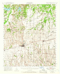 1947 Honey Grove1966 Print · USGSNortheast Texas at the close of the 1940s reveals a landscape of thriving rural school districts and rail-side commerce. Genealogists can trace family roots through numerous sites like McCraw Chapel, Oakwood Cem, and Michigan Prairie School.2 unique versions available
 - 1949 Map of Honey Grove
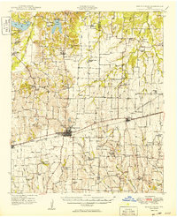 1949 Honey Grove1949 Print · USGSIn the late 1940s, the rural corridor between Honey Grove and Petty thrived as a network of rail-side towns and country schoolhouses. Genealogists can trace family landmarks like Spoonamore Hill, the Michigan Prairie School, and Oakwood Cem.
 - 1953 Map of Texarkana, 1964 Print
 1953 Texarkana1964 Print · USGSThe Texas-Arkansas borderlands are captured here in the mid-fifties, during a decade of massive military and hydraulic engineering projects. Genealogists and researchers can locate family landmarks like Old Boston Cem, Siloam Ch, and the vast Red River Arsenal.4 unique versions available
 - 1956 Map of Texarkana
 1956 Texarkana1956 Print · USGSThe Ark-La-Tex borderlands come alive in the mid-fifties, showing the transition from a rail-dependent rural economy to a post-war industrial landscape. Researchers can trace the massive Red River Ordnance Depot and find towns like Talco, Bogata, and Naples.
 - 1984 Map of Petty, 1985 Print
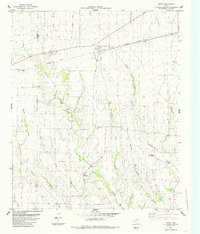 1984 Petty1985 Print · USGSThe rural landscape of Lamar and Fannin counties is captured here in the mid-1980s, centered on the railroad hub of Petty. Researchers can trace old family sites and rural settlements like Noble and White Rock or locate the Hickory Grove Cem.
 - 1984 Map of Honey Grove, 1985 Print
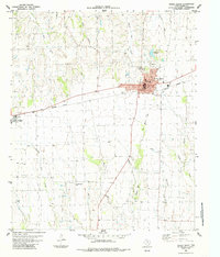 1984 Honey Grove1985 Print · USGSHoney Grove and Windom are captured here during the late 1970s as agricultural centers along the Missouri Pacific line. Genealogists and local historians can trace family locations near Mc Craws Chapel Cem, Oakwood Cem, and the Old Railroad Grade.
 - 1985 Map of Paris
 1985 Paris1985 Print · USGSThe Red River Valley in the mid-eighties shows a landscape of military training grounds and rail-connected agricultural towns. Genealogists and historians can trace local landmarks like Allens Chapel Cem, the grounds of Camp Maxey, and the early footprint of Paris Junior College.
 - 1991 Map of Paris
 1991 Paris1991 Print · USGSNorthern Texas and southern Oklahoma meet along the Red River valley during the early nineties. Researchers can trace the rail networks of the Texas and Pacific RR and visit rural communities like Manchester, Sylvan, and Arthur City.
End of results
Showing maps 1-9 of 9
Top cities near Honey Grove
- Cooper historical maps
- Wolfe City historical maps
- Roxton historical maps
- Ladonia historical maps
- Dodd City historical maps
- Windom historical maps
See more
Frequently asked questions
- What are the different types of historical maps available for Honey Grove?
- What is the oldest map of Honey Grove?
- Where can I purchase historical maps of Honey Grove for my home or office?
- Where can I download high-res historical maps of Honey Grove?
- Are there historical topographic maps available for Honey Grove?
- Is there historical aerial imagery available for Honey Grove?
- Where are historical maps of Honey Grove sourced from?