1960s Maps of Roby, Texas
Explore 4 historic maps of Roby from the 1960s. These maps offer a rare glimpse into what life looked like during the 1960s — showing old roads, neighborhoods, homes, and landmarks that have changed or disappeared over time.
Whether you're researching your family's past, planning a metal detecting trip, or studying how Roby's landscape evolved across the 1960s, these high-resolution maps are a powerful tool for exploring the history of this region.
- Focus on a specific era: All maps on this page are from the 1960s, giving you a focused view of this time period.
- See what’s changed: Compare century-old streets, trails, and buildings to today's modern landscape using overlays and satellite layers.
- Research with precision: Use these maps for genealogy, historical research, land use analysis, or educational projects.
- View, download, or print: Maps are fully viewable online in high resolution, and can be downloaded or printed for your own records.
Start exploring Roby's history through authentic maps from the 1960s. This is your window into the past.
Roby, TX maps
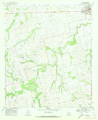
(4)- 1969 Map of Rotan, 1972 Print
 1969 Rotan1972 Print · USGSFisher County as it appeared in the late sixties reveals a landscape of industrial gypsum production and rail-fed commerce. Genealogists and historians can trace old property lines near Rotan Cem, the settlement of Sardis, and the Clear Fork Brazos River.2 unique versions available
 - 1969 Map of Roby, 1972 Print
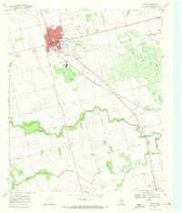
 1969 Roby1972 Print · USGSFisher County at the end of the sixties reveals a landscape shaped by ranching and the rising oil industry. Genealogists can trace family footprints near Roby, the Rodeo Ground, or rural landmarks like El Paso Ch and Liberty Ch.
 - 1969 Map of Longworth, 1973 Print
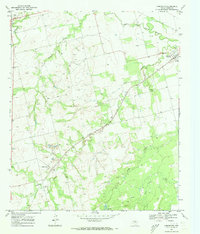 1969 Longworth1973 Print · USGSFisher County ranching and rail activity are captured here in the late sixties as the local economy balanced cattle and oil. Trace family history in Longworth and Sylvester, or follow the Atchison Topeka and Santa Fe line past the Sylvester Cem.
 - 1969 Map of Royston, 1973 Print
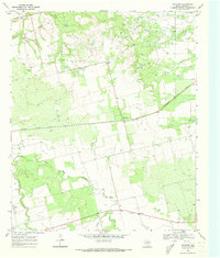 1969 Royston1973 Print · USGSFisher County in the late 1960s shows a landscape shaped by petroleum and the winding Clear Fork Brazos River. Researchers can trace the path of the Missouri Kansas Texas railroad and find local landmarks like the Roby Cem and Kyle Spring.2 unique versions available
End of results
Showing maps 1-4 of 4
Top cities near Roby
Frequently asked questions
- What are the different types of historical maps available for Roby?
- What is the oldest map of Roby?
- Where can I purchase historical maps of Roby for my home or office?
- Where can I download high-res historical maps of Roby?
- Are there historical topographic maps available for Roby?
- Is there historical aerial imagery available for Roby?
- Where are historical maps of Roby sourced from?