1930s Maps of Creekwood Estates, Friendswood
Explore 2 historic maps of Creekwood Estates from the 1930s. These maps offer a rare glimpse into what life looked like during the 1930s — showing old roads, neighborhoods, homes, and landmarks that have changed or disappeared over time.
Whether you're researching your family's past, planning a metal detecting trip, or studying how Creekwood Estates's landscape evolved across the 1930s, these high-resolution maps are a powerful tool for exploring the history of this region.
- Focus on a specific era: All maps on this page are from the 1930s, giving you a focused view of this time period.
- See what’s changed: Compare century-old streets, trails, and buildings to today's modern landscape using overlays and satellite layers.
- Research with precision: Use these maps for genealogy, historical research, land use analysis, or educational projects.
- View, download, or print: Maps are fully viewable online in high resolution, and can be downloaded or printed for your own records.
Start exploring Creekwood Estates's history through authentic maps from the 1930s. This is your window into the past.
Creekwood Estates, Friendswood maps
(2)- 1932 Map of Algoa
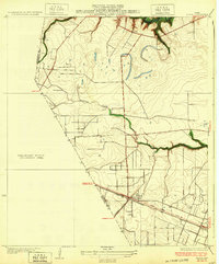 1932 Algoa1932 Print · USGSCoastal Texas in the early thirties centers on the railroad junction at Algoa, where steam-era transportation met the early automotive age. Genealogists and historians can trace the crossing of the Missouri Pacific and Gulf Colorado and Santa Fe near Dickinson Bayou.3 unique versions available
 - 1932 Map of Genoa
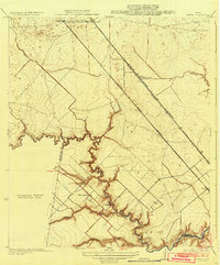 1932 Genoa1932 Print · USGSSoutheast Texas coastal prairie life in the early thirties is defined by emerging aviation and rail corridors. Genealogists can trace family footprints near Genoa or find the early layout of Olcott (Ellington Field) and the Friendswood Bridge.3 unique versions available
End of results
Showing maps 1-2 of 2
Frequently asked questions
- What are the different types of historical maps available for Creekwood Estates?
- What is the oldest map of Creekwood Estates?
- Where can I purchase historical maps of Creekwood Estates for my home or office?
- Where can I download high-res historical maps of Creekwood Estates?
- Are there historical topographic maps available for Creekwood Estates?
- Is there historical aerial imagery available for Creekwood Estates?
- Where are historical maps of Creekwood Estates sourced from?