1970s Maps of Seminole, Texas
Explore 2 historic maps of Seminole from the 1970s. These maps offer a rare glimpse into what life looked like during the 1970s — showing old roads, neighborhoods, homes, and landmarks that have changed or disappeared over time.
Whether you're researching your family's past, planning a metal detecting trip, or studying how Seminole's landscape evolved across the 1970s, these high-resolution maps are a powerful tool for exploring the history of this region.
- Focus on a specific era: All maps on this page are from the 1970s, giving you a focused view of this time period.
- See what’s changed: Compare century-old streets, trails, and buildings to today's modern landscape using overlays and satellite layers.
- Research with precision: Use these maps for genealogy, historical research, land use analysis, or educational projects.
- View, download, or print: Maps are fully viewable online in high resolution, and can be downloaded or printed for your own records.
Start exploring Seminole's history through authentic maps from the 1970s. This is your window into the past.
Seminole, TX maps
(2)- 1970 Map of Seminole NE, 1973 Print
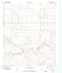 1970 Seminole NE1973 Print · USGSGaines County oil production was in full swing by the early seventies. Genealogists and historians can trace the development of Seminole East Oil Field and Wescott Oil Field, or locate the Fairview settlement.
 - 1970 Map of Seminole, 1974 Print
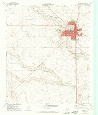 1970 Seminole1974 Print · USGSGaines County enters the seventies as a bustling hub of oil production and local commerce. Trace the mid-century layout of Seminole, from the Courthouse square to the Doss-Robertson Field and the local Drive-in Theater.
End of results
Showing maps 1-2 of 2
Top cities near Seminole
Top neighborhoods of Seminole
- Finley Moore historical maps
- West Sunset historical maps
- F M Wright historical maps
- Barnes & HItch historical maps
- W R Kitts Addition historical maps
- Mesquite Apartments historical maps
See more
Frequently asked questions
- What are the different types of historical maps available for Seminole?
- What is the oldest map of Seminole?
- Where can I purchase historical maps of Seminole for my home or office?
- Where can I download high-res historical maps of Seminole?
- Are there historical topographic maps available for Seminole?
- Is there historical aerial imagery available for Seminole?
- Where are historical maps of Seminole sourced from?