1900s (20th Century) Maps of Spanish Grant, Galveston
Explore 9 historic maps of Spanish Grant from the 1900s (20th Century). These maps offer a rare glimpse into what life looked like during the 1900s — showing old roads, neighborhoods, homes, and landmarks that have changed or disappeared over time.
Whether you're researching your family's past, planning a metal detecting trip, or studying how Spanish Grant's landscape evolved across the 1900s, these high-resolution maps are a powerful tool for exploring the history of this region.
- Focus on a specific era: All maps on this page are from the 1900s, giving you a focused view of this time period.
- See what’s changed: Compare century-old streets, trails, and buildings to today's modern landscape using overlays and satellite layers.
- Research with precision: Use these maps for genealogy, historical research, land use analysis, or educational projects.
- View, download, or print: Maps are fully viewable online in high resolution, and can be downloaded or printed for your own records.
Start exploring Spanish Grant's history through authentic maps from the 1900s. This is your window into the past.
Spanish Grant, Galveston maps
(9)- 1931 Map of Lake Como
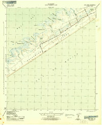
 1931 Lake Como1931 Print · USGSGalveston Island's coastal geography is shown in the early 1930s just as aerial mapping was coming into its own. Local historians can trace the early settlement at Dana and the natural shorelines of Lake Como and Sweetwater Lake before modern expansion.
 - 1933 Map of Lake Como, 1945 Print
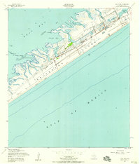
 1933 Lake Como1945 Print · USGSGalveston Island's central stretch appears in the early 1930s as a sparsely settled coastal landscape. Trace the early layout of Dana and examine the natural shorelines of Lake Como and Sweetwater Lake before decades of development.
 - 1943 Map of Lake Como
 1943 Lake Como1943 Print · USGSGalveston Island's central reaches are shown here in the early 1940s, highlighting the natural drainage systems and coastal topography. Trace the early road network from Eight Mile Road to Thirteen Mile Road while exploring landmarks like the Lookout Tower and Lake Como.2 unique versions available
 - 1950 Map of Houston, 1953 Print
 1950 Houston1953 Print · USGSCoastal Texas in the early fifties reveals a landscape of massive civil engineering and industrial transit. Genealogists and researchers can trace the growth of the Houston suburbs and the maritime infrastructure of Galveston Bay, including the Gulf Freeway and the Texas City Dike.
 - 1954 Map of Lake Como, 1958 Print
 1954 Lake Como1958 Print · USGSGalveston Island in the mid-fifties remains a world of open salt marshes and intricate bayous before the onset of modern expansion. Genealogists and historians can trace the early road network of Stewart Road and find coastal landmarks like Lake Como and Carancahua Reef.4 unique versions available
 - 1956 Map of Houston, 1963 Print
 1956 Houston1963 Print · USGSSoutheast Texas in the mid-fifties is captured here as a powerhouse of oil and maritime trade. Genealogists and historians can trace the foundations of Houston and its ports, alongside landmarks like the Rice Institute and the Spindletop Oil Field.2 unique versions available
 - 1975 Map of Houston, 1977 Print
 1975 Houston1977 Print · USGSThe Texas Gulf Coast in the mid-seventies shows a sprawling Houston metropolis linked to the sea by the massive Houston Ship Channel. Researchers can trace the mid-century industrial landscape from the Astrodome to the Lyndon B. Johnson Space Center.2 unique versions available
 - 1983 Map of Galveston
 1983 Galveston1983 Print · USGSThe Texas Gulf Coast comes into sharp focus in the early eighties, centered on the thriving maritime and industrial hubs of Galveston and Texas City. Trace coastal change and land use through landmarks like Fort San Jacinto, the Texas City Dike, and the expansive Galveston Island State Park.
 - 1994 Map of Lake Como
 1994 Lake Como1994 Print · USGSGalveston Island's western reach is shown in the mid-1990s, where residential growth meets protected coastal marshes. Researchers can trace the development of Jamaica Beach or locate historical landmarks like Lafitte Grove and the Mary Moody Northern Amphitheater Footbridge.
End of results
Showing maps 1-9 of 9
Frequently asked questions
- What are the different types of historical maps available for Spanish Grant?
- What is the oldest map of Spanish Grant?
- Where can I purchase historical maps of Spanish Grant for my home or office?
- Where can I download high-res historical maps of Spanish Grant?
- Are there historical topographic maps available for Spanish Grant?
- Is there historical aerial imagery available for Spanish Grant?
- Where are historical maps of Spanish Grant sourced from?