Old Maps of Galveston, Texas
Explore 52 old maps of Galveston, spanning from 1929 to today. These high-resolution historic maps reveal how streets, neighborhoods, landmarks, and natural features evolved over time — perfect for genealogy, metal detecting, research, and local history exploration.
What you can do with these maps:
- See how Galveston changed over time: Compare historical maps to modern-day views to trace roads, homesites, rail lines & more.
- View detailed metadata: Each map includes creators, publishers, year, scale, and archive source.
- Overlay maps with satellite & LiDAR: Visualize the past alongside modern tools to explore terrain & human change.
- Trusted historical sources: Maps sourced from the USGS, Library of Congress, and other archives.
- Access maps your way: View online, download high-res files, or order prints for personal or research use.
Start exploring old maps of Galveston to uncover forgotten places, hidden landmarks, and the deep history beneath your feet.
Galveston, TX maps
(52)- 1929 Map of Karankawa Lake
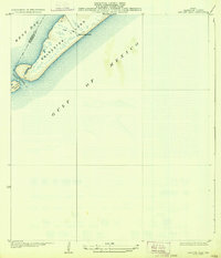
 1929 Karankawa Lake1929 Print · USGSThe Galveston and Brazoria county line meets the Gulf Coast in the late 1920s, revealing an era of undeveloped marshland and barrier island terrain. Researchers can trace the shifting shoreline of Galveston Island and identify historical landmarks like Karankawa Lake and Halls.
 - 1929 Map of Virginia Point
 1929 Virginia Point1929 Print · USGSThe Galveston shoreline in the late twenties was a hub of heavy industry and rail transport as the region expanded toward the mainland. Family historians can trace the early layout of La Marque and the dense rail junctions at Texas City Junction and Virginia Point.
 - 1930 Map of Galveston
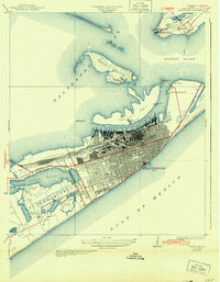
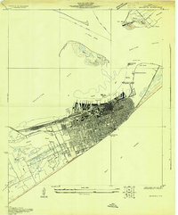 1930 Galveston1930 Print · USGSGalveston thrived as a premier Gulf port and rail terminus during the interwar years. Genealogists and maritime historians can trace the harbor's layout through Union Station, the Fort Crockett Flying Field, and the Immigrant Station.
 - 1931 Map of Lake Como
 1931 Lake Como1931 Print · USGSGalveston Island's coastal geography is shown in the early 1930s just as aerial mapping was coming into its own. Local historians can trace the early settlement at Dana and the natural shorelines of Lake Como and Sweetwater Lake before modern expansion.
 - 1931 Map of Flake
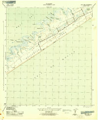
 1931 Flake1931 Print · USGSGalveston County's coastal landscape appears in 1931 as a network of rail lines and marshes on the Bolivar Peninsula. Researchers can trace the early footprint of the Flake settlement and locate landmarks like Parrs Grove and Elm Grove.
 - 1932 Map of Virginia Point, 1943 Print
 1932 Virginia Point1943 Print · USGSThe Galveston mainland in the late twenties was a hub of industrial transit, dominated by rail lines converging at the shore. Trace the path of the Interurban and Southern Pacific as they reach Virginia Point and the Galveston Causeway.
 - 1933 Map of The Jetties
 1933 The Jetties1933 Print · USGSCoastal Galveston in the early thirties highlights the massive maritime infrastructure protecting the harbor entrance. Researchers can trace the layout of the North Jetty and South Jetty and locate the offshore Galveston Jetty LH.2 unique versions available
 - 1933 Map of Karankawa Lake
 1933 Karankawa Lake1933 Print · USGSThe Galveston coastline in the early 1930s is captured here, showing the unbridled geography of Galveston Island and the bay. Researchers can trace the original shoreline and water features like Karankawa Lake, Karankawa Point, and Lake Como.2 unique versions available
 - 1933 Map of Flake
 1933 Flake1933 Print · USGSThe Texas coast at the Bolivar Peninsula is captured here in the early 1930s as a corridor of rail and road. Researchers can trace the early path of the Gulf Colorado and Santa Fe railroad and the small settlement at Flake.2 unique versions available
 - 1933 Map of San Luis Pass
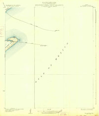
 1933 San Luis Pass1933 Print · USGSThe southwestern tip of Galveston Island is captured in the early 1930s, showing the maritime landscape before modern bridge connections. Trace the coastal defenses and tidal inlets of the era, from the San Luis Coast Guard station to the waters of West Bay.2 unique versions available
 - 1933 Map of Galveston, 1943 Print
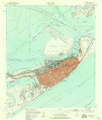
 1933 Galveston1943 Print · USGSGalveston and the Bolivar Peninsula are shown in the early 1930s as a major hub for rail, sea, and military defense. Trace the dense network of rail lines ending at Union Sta, the numerous harbor docks, and coastal fortifications like Fort Crockett and Fort Travis.
 - 1933 Map of Lake Como, 1945 Print
 1933 Lake Como1945 Print · USGSGalveston Island's central stretch appears in the early 1930s as a sparsely settled coastal landscape. Trace the early layout of Dana and examine the natural shorelines of Lake Como and Sweetwater Lake before decades of development.
 - 1943 Map of San Luis Pass
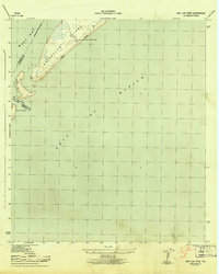 1943 San Luis Pass1943 Print · USGSCoastal Galveston during the war years focused on maritime defense and navigation at the mouth of the bay. Researchers can trace the early layout of West Beach and the location of the San Luis Coast Guard Station at San Luis Pass.3 unique versions available
 - 1943 Map of Virginia Point
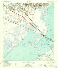
 1943 Virginia Point1943 Print · USGSGalveston County was a hive of industrial and maritime activity during the war years. Local historians can trace the critical rail lines of the Santa Fe and the strategic connection at Virginia Point leading toward Galveston Island.2 unique versions available
 - 1943 Map of Lake Como
 1943 Lake Como1943 Print · USGSGalveston Island's central reaches are shown here in the early 1940s, highlighting the natural drainage systems and coastal topography. Trace the early road network from Eight Mile Road to Thirteen Mile Road while exploring landmarks like the Lookout Tower and Lake Como.2 unique versions available
 - 1943 Map of Flake
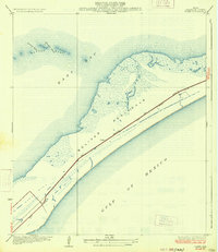
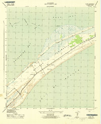 1943 Flake1943 Print · USGSThe Bolivar Peninsula appears here during the early 1940s, showing its vital coastal role between the Gulf and the Galveston Bay system. Historians can trace the wartime landscape near Flake, including the Lookout Tower and Port Bolivar Cem.2 unique versions available
 - 1943 Map of The Jetties, 1952 Print
 1943 The Jetties1952 Print · USGSThe Galveston coastline during the early 1940s reveals the intricate maritime engineering used to guide ships through the Bolivar Roads. Trace the alignment of the South Jetty Lighthouse and North Jetty Light guarding the Outer Bar Channel.
 - 1943 Map of Carancahua Lake, 1952 Print
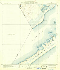
 1943 Carancahua Lake1952 Print · USGSThe Galveston and Brazoria county line met in the tidal marshes and open waters of the West Bay during the 1940s. Researchers can trace the early path of the Intracoastal Waterway and locate landmarks like Rattlesnake Mound and Boathouse Ruins.
 - 1943 Map of Galveston, 1952 Print
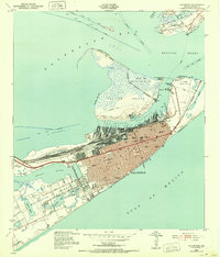 1943 Galveston1952 Print · USGSGalveston at the height of the mid-century maritime era is a dense landscape of coastal defenses and rail terminals. Researchers can trace the legacy of the Southern Pacific lines or locate old military installations like Old Fort San Jacinto and Fort Crockett.
 - 1943 Map of Christmas Point, 1958 Print
 1943 Christmas Point1958 Print · USGSThe Texas Gulf Coast at Christmas Bay appears here in the 1940s, showing a landscape of barrier islands and marshy bayous. Trace the historic route of the Intracoastal Waterway and locate early landmarks like Christmas Point and Rattlesnake Point.
 - 1950 Map of Houston, 1953 Print
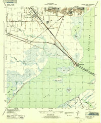
 1950 Houston1953 Print · USGSCoastal Texas in the early fifties reveals a landscape of massive civil engineering and industrial transit. Genealogists and researchers can trace the growth of the Houston suburbs and the maritime infrastructure of Galveston Bay, including the Gulf Freeway and the Texas City Dike.
 - 1951 Map of Bay City
 1951 Bay City1951 Print · USGSThe mid-century Texas Gulf Coast comes to life in this survey of the delta region where the Brazos and Colorado Rivers meet the sea. Researchers can trace the industrial footprint of Freeport or locate family-named spots like Mangun and Hawkinsville.
 - 1954 Map of Virginia Point, 1956 Print
 1954 Virginia Point1956 Print · USGSThe Galveston Bay shoreline in the mid-fifties reveals a critical junction of rail and maritime industry. Trace the infrastructure of the Texas City Terminal, old neighborhood schools like Highlands Sch, and the original Galveston Causeway.3 unique versions available
 - 1954 Map of Galveston, 1958 Print
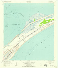
 1954 Galveston1958 Print · USGSMid-century Galveston is shown at its peak as a maritime and rail center, guarded by coastal defenses. Genealogists and historians can locate dozens of institutions like the University of Texas Medical College and Ball High Sch, or trace the old railroad grades across the island.4 unique versions available
 - 1954 Map of Flake, 1958 Print
 1954 Flake1958 Print · USGSThe Bolivar Peninsula in the mid-1950s shows a landscape of coastal communities and maritime infrastructure. Genealogists and historians can trace the Port Bolivar Cem, the Old Railroad Grade, and small settlements like Flake.4 unique versions available
Showing maps 1-25 of 52
Top cities near Galveston
- Texas City historical maps
- La Marque historical maps
- Santa Fe historical maps
- Hitchcock historical maps
- Port Bolivar historical maps
- Bayou Vista historical maps
See more
Top neighborhoods of Galveston
- Campeche Cove historical maps
- Anderson Ways historical maps
- Bay Harbor historical maps
- Beachtown historical maps
- Beachtown historical maps
- Pirates Cove historical maps
See more
Frequently asked questions
- What are the different types of historical maps available for Galveston?
- What is the oldest map of Galveston?
- Where can I purchase historical maps of Galveston for my home or office?
- Where can I download high-res historical maps of Galveston?
- Are there historical topographic maps available for Galveston?
- Is there historical aerial imagery available for Galveston?
- Where are historical maps of Galveston sourced from?