1960s Maps of Galveston, Texas
Explore 3 historic maps of Galveston from the 1960s. These maps offer a rare glimpse into what life looked like during the 1960s — showing old roads, neighborhoods, homes, and landmarks that have changed or disappeared over time.
Whether you're researching your family's past, planning a metal detecting trip, or studying how Galveston's landscape evolved across the 1960s, these high-resolution maps are a powerful tool for exploring the history of this region.
- Focus on a specific era: All maps on this page are from the 1960s, giving you a focused view of this time period.
- See what’s changed: Compare century-old streets, trails, and buildings to today's modern landscape using overlays and satellite layers.
- Research with precision: Use these maps for genealogy, historical research, land use analysis, or educational projects.
- View, download, or print: Maps are fully viewable online in high resolution, and can be downloaded or printed for your own records.
Start exploring Galveston's history through authentic maps from the 1960s. This is your window into the past.
Galveston, TX maps
(3)- 1963 Map of Sea Isle, 1966 Print
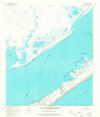 1963 Sea Isle1966 Print · USGSGalveston Island shows its mid-century growth as new coastal communities emerge along the Gulf. Genealogists and historians can trace early developments at Sea Isle and Bay Harbor or locate family landmarks like the Fishing Cabins on Halls Bayou.3 unique versions available
 - 1963 Map of San Luis Pass, 1966 Print
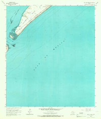 1963 San Luis Pass1966 Print · USGSThe southwestern tip of Galveston Island and the waters of San Luis Pass are captured here in the early 1960s. Genealogists and coastal historians can trace early island life near Bay Harbor and along West Beach.2 unique versions available
 - 1965 Map of Christmas Point, 1966 Print
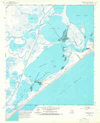 1965 Christmas Point1966 Print · USGSThe Brazoria County coastline in the mid-sixties reveals a dynamic landscape of barrier islands and industrial navigation. Researchers can trace the path of the Intracoastal Waterway or locate local landmarks like the Landing Strip and Arcadia Reef.3 unique versions available
End of results
Showing maps 1-3 of 3
Top cities near Galveston
- Texas City historical maps
- La Marque historical maps
- Santa Fe historical maps
- Hitchcock historical maps
- Port Bolivar historical maps
- Bayou Vista historical maps
See more
Top neighborhoods of Galveston
- Campeche Cove historical maps
- Anderson Ways historical maps
- Bay Harbor historical maps
- Spanish Grant historical maps
- Isla del Sol historical maps
- Sunset Cove historical maps
See more
Frequently asked questions
- What are the different types of historical maps available for Galveston?
- What is the oldest map of Galveston?
- Where can I purchase historical maps of Galveston for my home or office?
- Where can I download high-res historical maps of Galveston?
- Are there historical topographic maps available for Galveston?
- Is there historical aerial imagery available for Galveston?
- Where are historical maps of Galveston sourced from?