Old Maps of La Marque, Texas
Explore 29 old maps of La Marque, spanning from 1929 to today. These high-resolution historic maps reveal how streets, neighborhoods, landmarks, and natural features evolved over time — perfect for genealogy, metal detecting, research, and local history exploration.
What you can do with these maps:
- See how La Marque changed over time: Compare historical maps to modern-day views to trace roads, homesites, rail lines & more.
- View detailed metadata: Each map includes creators, publishers, year, scale, and archive source.
- Overlay maps with satellite & LiDAR: Visualize the past alongside modern tools to explore terrain & human change.
- Trusted historical sources: Maps sourced from the USGS, Library of Congress, and other archives.
- Access maps your way: View online, download high-res files, or order prints for personal or research use.
Start exploring old maps of La Marque to uncover forgotten places, hidden landmarks, and the deep history beneath your feet.
La Marque, TX maps
(29)- 1929 Map of Dickinson
 1929 Dickinson1929 Print · USGSGalveston County is captured here in the late twenties, showing a landscape defined by tidewater bayous and competing transit lines. Trace early rail corridors like the Missouri Pacific and find local landmarks such as Arcadia and the Santa Fe Sch.
 - 1929 Map of Hitchcock
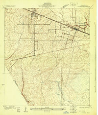 1929 Hitchcock1929 Print · USGSCoastal Galveston County is captured here in the late twenties, showing the transition from inland prairie to marshy bayou. Genealogists and historians can trace early infrastructure along the Gulf Colorado and Santa Fe Railway near Hitchcock and Alta Loma.
 - 1929 Map of Virginia Point
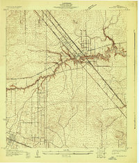
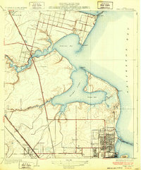
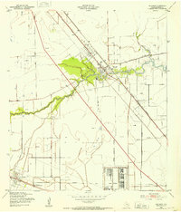
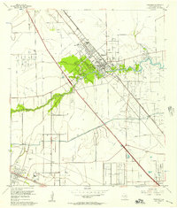
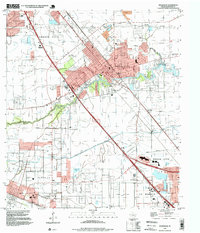
 1929 Virginia Point1929 Print · USGSThe Galveston shoreline in the late twenties was a hub of heavy industry and rail transport as the region expanded toward the mainland. Family historians can trace the early layout of La Marque and the dense rail junctions at Texas City Junction and Virginia Point.
 - 1929 Map of Texas City
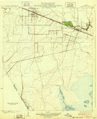
 1929 Texas City1929 Print · USGSCoastal Galveston County is caught in a moment of early industrial and transit growth during the late twenties. Genealogists and historians can trace the early grids of Texas City and Lamarque, or locate coastal landmarks like Clifton By the Sea and April Fool Point.
 - 1932 Map of Dickinson
 1932 Dickinson1932 Print · USGSGalveston County was a bustling hub of rail and road traffic in the early thirties, centered on the winding waters of the Dickinson Bayou. Researchers can trace the routes of the Houston Galveston Electric line and locate local landmarks like the Santa Fe Sch in Arcadia.2 unique versions available
 - 1932 Map of Texas City
 1932 Texas City1932 Print · USGSThe Galveston County coast in the early 1930s shows a landscape defined by rail lines and nascent port infrastructure. Genealogists and historians can trace the early grids of Texas City and locate coastal communities like Clifton by the Sea and San Leon.2 unique versions available
 - 1932 Map of Hitchcock
 1932 Hitchcock1932 Print · USGSThe coastal prairies of Galveston County come into focus during the early thirties as rail and ranching shaped the landscape. Genealogists and local researchers can trace early settlements at Hitchcock and Alta Loma, or locate the Galveston Memorial Cemetery near the banks of Highland Bayou.2 unique versions available
 - 1932 Map of Virginia Point, 1943 Print
 1932 Virginia Point1943 Print · USGSThe Galveston mainland in the late twenties was a hub of industrial transit, dominated by rail lines converging at the shore. Trace the path of the Interurban and Southern Pacific as they reach Virginia Point and the Galveston Causeway.
 - 1943 Map of Virginia Point
 1943 Virginia Point1943 Print · USGSGalveston County was a hive of industrial and maritime activity during the war years. Local historians can trace the critical rail lines of the Santa Fe and the strategic connection at Virginia Point leading toward Galveston Island.2 unique versions available
 - 1943 Map of Texas City
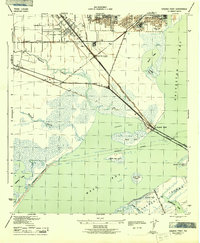
 1943 Texas City1943 Print · USGSThe Galveston Bay shoreline and the industrial expansion of the Texas City area are captured in detail during the early 1940s. Genealogists and local historians can trace the early layouts of Lamarque, the waterfront at San Leon, and the rail infrastructure of the Southern Pacific.2 unique versions available
 - 1943 Map of Dickinson, 1953 Print
 1943 Dickinson1953 Print · USGSCoastal Galveston County comes alive during the war years, showing a landscape defined by military sites and the winding Dickinson Bayou. You can trace family roots at Arcadia, locate the Santa Fe Consolidated Sch, and explore the layout of Camp Wallace.
 - 1950 Map of Hitchcock
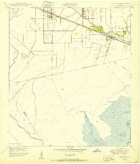 1950 Hitchcock1950 Print · USGSGalveston County settlement at mid-century is centered on the railroad corridor between the coastal prairies and the marshy bayous. Researchers can trace family-named routes like Bene Road and Jay Road or locate the Alta Loma Cemetery and Camp Wallace Military Reservation.
 - 1950 Map of Houston, 1953 Print
 1950 Houston1953 Print · USGSCoastal Texas in the early fifties reveals a landscape of massive civil engineering and industrial transit. Genealogists and researchers can trace the growth of the Houston suburbs and the maritime infrastructure of Galveston Bay, including the Gulf Freeway and the Texas City Dike.
 - 1954 Map of Virginia Point, 1956 Print
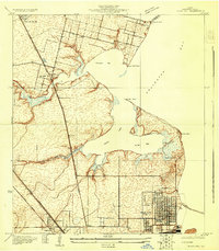
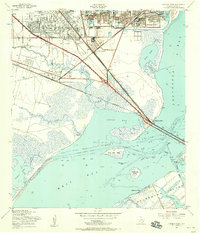 1954 Virginia Point1956 Print · USGSThe Galveston Bay shoreline in the mid-fifties reveals a critical junction of rail and maritime industry. Trace the infrastructure of the Texas City Terminal, old neighborhood schools like Highlands Sch, and the original Galveston Causeway.3 unique versions available
 - 1954 Map of Texas City, 1958 Print
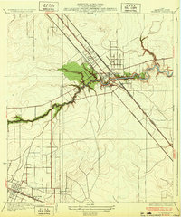
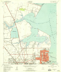 1954 Texas City1958 Print · USGSThe industrial heart of the Texas coast is captured here during the mid-fifties, showing the rapid growth of Texas City and La Marque. Genealogists and historians can trace neighborhood developments around St Marys Ch, the early Gulf Coast Airport, and the massive Texas City Dike.3 unique versions available
 - 1955 Map of Dickinson, 1957 Print
 1955 Dickinson1957 Print · USGSCoastal Galveston County comes into focus in the mid-fifties as it balances petroleum production with growing residential communities. Genealogists and historians can trace the tracks of the Gulf Colorado and Santa Fe through Arcadia or locate family sites near Mt Olivet Cemetery.5 unique versions available
 - 1956 Map of Houston, 1963 Print
 1956 Houston1963 Print · USGSSoutheast Texas in the mid-fifties is captured here as a powerhouse of oil and maritime trade. Genealogists and historians can trace the foundations of Houston and its ports, alongside landmarks like the Rice Institute and the Spindletop Oil Field.2 unique versions available
 - 1964 Map of Hitchcock, 1966 Print
 1964 Hitchcock1966 Print · USGSGalveston County’s industrial and coastal landscape is captured here in the mid-1960s, showing the intersection of petroleum production and community growth. Genealogists and historians can trace family locations near Alta Loma Cem, Crosby High Sch, and the extensive Sarah White Oil Field.4 unique versions available
 - 1975 Map of Houston, 1977 Print
 1975 Houston1977 Print · USGSThe Texas Gulf Coast in the mid-seventies shows a sprawling Houston metropolis linked to the sea by the massive Houston Ship Channel. Researchers can trace the mid-century industrial landscape from the Astrodome to the Lyndon B. Johnson Space Center.2 unique versions available
 - 1983 Map of Galveston
 1983 Galveston1983 Print · USGSThe Texas Gulf Coast comes into sharp focus in the early eighties, centered on the thriving maritime and industrial hubs of Galveston and Texas City. Trace coastal change and land use through landmarks like Fort San Jacinto, the Texas City Dike, and the expansive Galveston Island State Park.
 - 1984 Map of Angleton
 1984 Angleton1984 Print · USGSThe Texas Gulf Coast in the mid-eighties shows a landscape of salt domes and bayous at the height of its oil-and-river economy. Researchers can trace land use through the Damon Mound Oil Field and the sprawling State Department of Corrections (Retrieve Unit).2 unique versions available
 - 1994 Map of Texas City
 1994 Texas City1994 Print · USGSTexas City and the Galveston Bay shoreline are captured here in the mid-1990s, showcasing a landscape of industrial infrastructure and coastal protection. Genealogists and historians can trace neighborhood developments like Bacliff and San Leon, or locate family markers at Texas City Memorial Cem and Phillips Memorial Cem.
 - 1994 Map of Virginia Point
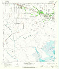
 1994 Virginia Point1994 Print · USGSThe Texas Gulf Coast in the early nineties shows the dense intersection of industrial shipping and modern canal-front living. Trace the transition from the mainland to Galveston Island via Virginia Point, or locate local landmarks like Lamar Cem and the Village of Tiki Island.
 - 1995 Map of Dickinson, 1999 Print
 1995 Dickinson1999 Print · USGSCoastal Galveston County is captured here during a period of significant suburban and industrial growth. Researchers can trace the legacy of Camp Wallace, locate the Mt Olivet Cemetery, and explore the reaches of Dickinson Bayou.
 - 1995 Map of Virginia Point, 2000 Print
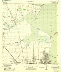
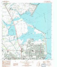
 1995 Virginia Point2000 Print · USGSThe Texas Gulf Coast comes into focus in the mid-nineties as industrial centers and master-planned waterfront communities expand toward the bay. Genealogists and historians can trace the development of Tiki Island and find local landmarks like La Marque Cem and Texas City Terminal Junction.
Showing maps 1-25 of 29
Top cities near La Marque
- Houston historical maps
- Pasadena historical maps
- Pearland historical maps
- League City historical maps
- Galveston historical maps
- Texas City historical maps
See more
Frequently asked questions
- What are the different types of historical maps available for La Marque?
- What is the oldest map of La Marque?
- Where can I purchase historical maps of La Marque for my home or office?
- Where can I download high-res historical maps of La Marque?
- Are there historical topographic maps available for La Marque?
- Is there historical aerial imagery available for La Marque?
- Where are historical maps of La Marque sourced from?