
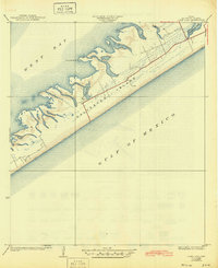
1929 Map of Karankawa Lake
USGS Topo · Published 1929About this map
Galveston Island and the coastal marshes of the Texas mainland define this 1929 survey, which documents the fragile interface between land and water before significant modern development. The landscape is dominated by the West Bay and the intricate wetlands surrounding Karankawa Lake. On the mainland side, small features like Halls and a series of survey monuments such as Mon 26 and Mon 27 track the jurisdictional boundary between Galveston and Brazoria counties. This advance sheet reflects an era of transitioning cartographic techniques, noted in the margin as using aerial photography from the Army Air Corps to map the island's culture and drainage. The presence of features like Karankawa Point and the isolated label Snake along the bay's edge offer specific points of interest for those studying the natural history and early surveying of the Texas Gulf Coast.
Find a feature on this map
18 named features on this map. Tap any name to fly to it.
Don’t see what you’re looking for? This feature index may not catch every label — zoom into the map to look around manually.
Map Details
Editions of this 1929 Karankawa Lake Map
This is the sole edition of this map. No revisions or reprints were ever made.
Other maps of this area

1929 · Hitchcock
USGS Topo · 1:24,000

1929 · Virginia Point
USGS Topo · 1:24,000

1931 · Lake Como
USGS Topo · 1:24,000

1932 · Hitchcock
USGS Topo · 1:31,680

1932 · Mustang Bayou
USGS Topo · 1:31,680

1932 · Virginia Point
USGS Topo · 1:31,680

1933 · Karankawa Lake
USGS Topo · 1:31,680

1933 · San Luis Pass
USGS Topo · 1:31,680
1933 · Lake Como
USGS Topo · 1:31,680

1943 · San Luis Pass
USGS Topo · 1:31,680