
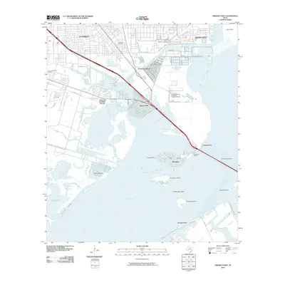
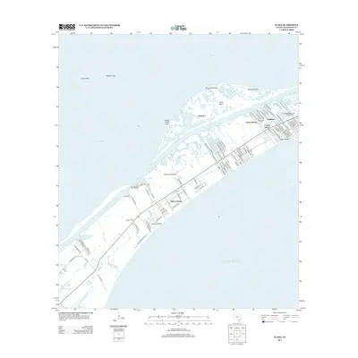
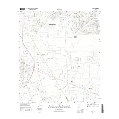
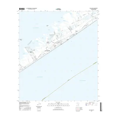
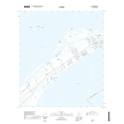
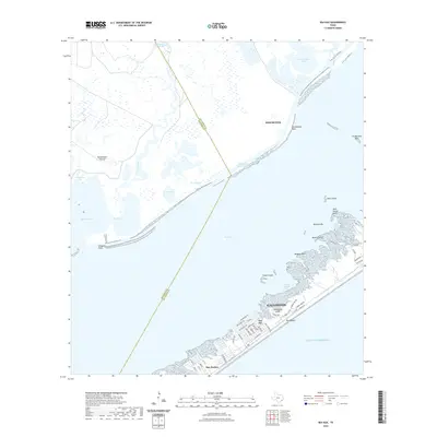
1932 Map of Virginia Point
USGS Topo · Published 1943About this map
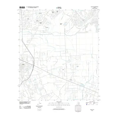
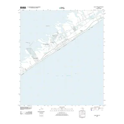
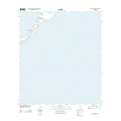
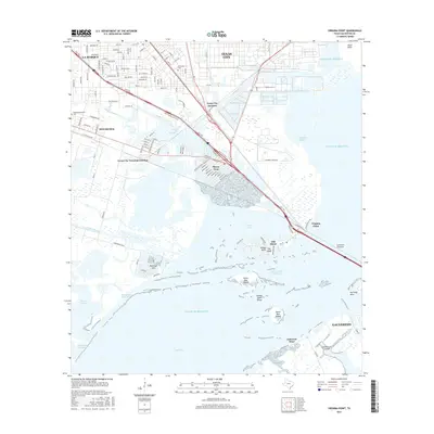
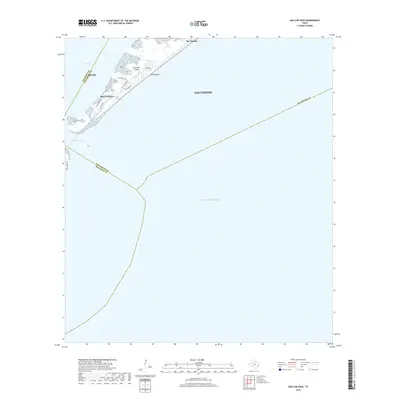
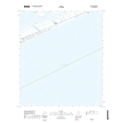
Virginia Point serves as the critical transit bottleneck in this 1929 survey, where a massive concentration of rail and road infrastructure converges to cross the Galveston Causeway. The map captures the industrial and maritime layout of Texas City and Lamarque during a period of significant coastal development. Multiple rail lines, including the Southern Pacific, the Interurban, and the Galveston Houston and Henderson, dominate the landscape, illustrating the complex logistics of the Galveston Bay area before mid-century expansion. The coastal topography is defined by intricate wetland systems like Swan Lake and Campbell Bayou, while Dredge Dumps near the harbor signify ongoing efforts to maintain deep-water access. This document is particularly valuable for tracing the original footprint of the Houston City Electric line and the early rail junctions that powered the region's shipping economy.
Find a feature on this map
30 named features on this map. Tap any name to fly to it.
Don’t see what you’re looking for? This feature index may not catch every label — zoom into the map to look around manually.
Map Details
Editions of this 1932 Virginia Point Map
This is the sole edition of this map. No revisions or reprints were ever made.
Historical Maps of Galveston Through Time
96 maps found

1929 Algoa
Galveston County, TX

1929 Karankawa Lake
Galveston County, TX

1929 Virginia Point
Galveston County, TX

1931 Flake
Galveston County, TX

1931 Lake Como
Galveston County, TX

1932 Algoa
Galveston County, TX

1932 Bolivar Point
Galveston County, TX
1932 Virginia Point
Galveston County, TX

1933 Bolivar Point
Galveston County, TX

1933 Caplen
Galveston County, TX

1933 Carancahua Lake
Galveston County, TX

1933 Flake
Galveston County, TX

1933 Lake Como
Galveston County, TX

1933 San Luis Pass
Galveston County, TX

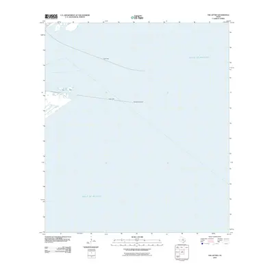
1933 The Jetties
Galveston County, TX

1943 Caplen
Galveston County, TX

1943 Carancahua Lake
Galveston County, TX

1943 Flake
Galveston County, TX

1943 Lake Como
Galveston County, TX

1943 Port Bolivar
Galveston County, TX

1943 San Luis Pass
Galveston County, TX

1943 The Jetties
Galveston County, TX

1943 Virginia Point
Galveston County, TX

1954 Caplen
Galveston County, TX

1954 Flake
Galveston County, TX

1954 Lake Como
Galveston County, TX

1954 Port Bolivar
Galveston County, TX

1954 The Jetties
Galveston County, TX

1954 Virginia Point
Galveston County, TX

1956 Algoa
Galveston County, TX

1963 San Luis Pass
Galveston County, TX

1963 Sea Isle
Galveston County, TX

1994 Caplen
Galveston County, TX

1994 Flake
Galveston County, TX

1994 Lake Como
Galveston County, TX

1994 Port Bolivar
Galveston County, TX

1994 The Jetties
Galveston County, TX

1994 Virginia Point
Galveston County, TX

1995 Virginia Point
Galveston County, TX
2010 Algoa
Galveston County, TX
2010 Caplen
Galveston County, TX
2010 Flake
Galveston County, TX
2010 Galveston OE S
Galveston County, TX
2010 Lake Como
Galveston County, TX
2010 Port Bolivar
Galveston County, TX
2010 San Luis Pass
Galveston County, TX
2010 Sea Isle
Galveston County, TX
2010 The Jetties
Galveston County, TX
2010 Virginia Point
Galveston County, TX
2013 Algoa
Galveston County, TX
2013 Caplen
Galveston County, TX
2013 Flake
Galveston County, TX
2013 Galveston OE S
Galveston County, TX
2013 Lake Como
Galveston County, TX
2013 Port Bolivar
Galveston County, TX
2013 San Luis Pass
Galveston County, TX
2013 Sea Isle
Galveston County, TX
2013 The Jetties
Galveston County, TX
2013 Virginia Point
Galveston County, TX
2016 Algoa
Galveston County, TX
2016 Caplen
Galveston County, TX
2016 Flake
Galveston County, TX
2016 Galveston OE S
Galveston County, TX
2016 Lake Como
Galveston County, TX
2016 Port Bolivar
Galveston County, TX
2016 San Luis Pass
Galveston County, TX
2016 Sea Isle
Galveston County, TX
2016 The Jetties
Galveston County, TX
2016 Virginia Point
Galveston County, TX
2019 Algoa
Galveston County, TX
2019 Caplen
Galveston County, TX
2019 Flake
Galveston County, TX
2019 Galveston OE S
Galveston County, TX
2019 Lake Como
Galveston County, TX
2019 Port Bolivar
Galveston County, TX
2019 San Luis Pass
Galveston County, TX
2019 Sea Isle
Galveston County, TX
2019 The Jetties
Galveston County, TX
2019 Virginia Point
Galveston County, TX

2022 Algoa
Galveston County, TX
2022 Caplen
Galveston County, TX
2022 Flake
Galveston County, TX

2022 Galveston OE S
Galveston County, TX
2022 Lake Como
Galveston County, TX

2022 Port Bolivar
Galveston County, TX
2022 San Luis Pass
Galveston County, TX
2022 Sea Isle
Galveston County, TX
2022 The Jetties
Galveston County, TX

2022 Virginia Point
Galveston County, TX

2025 Caplen
Galveston County, TX

2025 Flake
Galveston County, TX

2025 Galveston OE S
Galveston County, TX

2025 Lake Como
Galveston County, TX

2025 San Luis Pass
Galveston County, TX

2025 Sea Isle
Galveston County, TX

2025 The Jetties
Galveston County, TX