
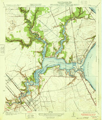
1929 Map of Texas City
USGS Topo · Published 1929About this map
Texas City serves as the industrial and urban anchor of this coastal survey, displaying an emerging street grid and harbor facilities on the shores of Galveston Bay. In the late 1920s, this portion of Galveston County was defined by its relationship with the water and the railroads, with the Southern Pacific and the Galveston Houston Electric lines providing critical transit through settlements like Lamarque and San Leon Sta. The intricate shoreline is punctuated by notable landmarks such as April Fool Point, Miller Point, and Dollar Point, which frame the shallow reaches of Moses Lake and Dollar Bay. A unique geological detail includes several areas marked as Gas Bumps near the coast, suggesting the subterranean pressures that would become central to the region's energy economy. Further north, the coastal community of Clifton By the Sea and the original townsite of San Leon illustrate the early development of the Galveston bayfront before mid-century expansion.
Find a feature on this map
20 named features on this map. Tap any name to fly to it.
Don’t see what you’re looking for? This feature index may not catch every label — zoom into the map to look around manually.
Map Details
Editions of this 1929 Texas City Map
This is the sole edition of this map. No revisions or reprints were ever made.
Other maps of this area

1916 · Seabrook
USGS Topo · 1:24,000

1920 · Seabrook
USGS Topo · 1:31,680

1929 · Dickinson
USGS Topo · 1:24,000

1929 · Hitchcock
USGS Topo · 1:24,000

1929 · Virginia Point
USGS Topo · 1:24,000

1930 · Galveston
USGS Topo · 1:24,000

1932 · Clifton By The Sea
USGS Topo · 1:31,680

1932 · Dickinson
USGS Topo · 1:31,680
1932 · Seabrook
USGS Topo · 1:31,680

1932 · Texas City
USGS Topo · 1:31,680