
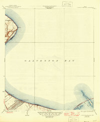
1932 Map of Clifton By The Sea
USGS Topo · Published 1932About this map
Clifton by the Sea and the surrounding shoreline of Galveston Bay are captured here during a period of transition in the early 1930s. The map illustrates a coastal landscape defined by maritime navigation and rail transport, featuring the Southern Pacific railroad running along the western edge near Red Bluff. The settlement of Bayview appears just north of the larger grid of Clifton by the Sea, offering a glimpse into the early residential layout of this stretch of the Texas coast.
Find a feature on this map
11 named features on this map. Tap any name to fly to it.
Don’t see what you’re looking for? This feature index may not catch every label — zoom into the map to look around manually.
Map Details
Editions of this 1932 Clifton By The Sea Map
2 editions found
Other maps of this area

1916 · Morgan Point
USGS Topo · 1:24,000

1916 · Seabrook
USGS Topo · 1:24,000

1916 · La Porte
USGS Topo · 1:24,000

1919 · Morgan Point
USGS Topo · 1:31,680

1920 · Seabrook
USGS Topo · 1:31,680

1920 · La Porte
USGS Topo · 1:31,680

1929 · Dickinson
USGS Topo · 1:24,000

1929 · Texas City
USGS Topo · 1:24,000

1932 · Dickinson
USGS Topo · 1:31,680
1932 · Seabrook
USGS Topo · 1:31,680